Safe Structures Program
Safe Structures Program
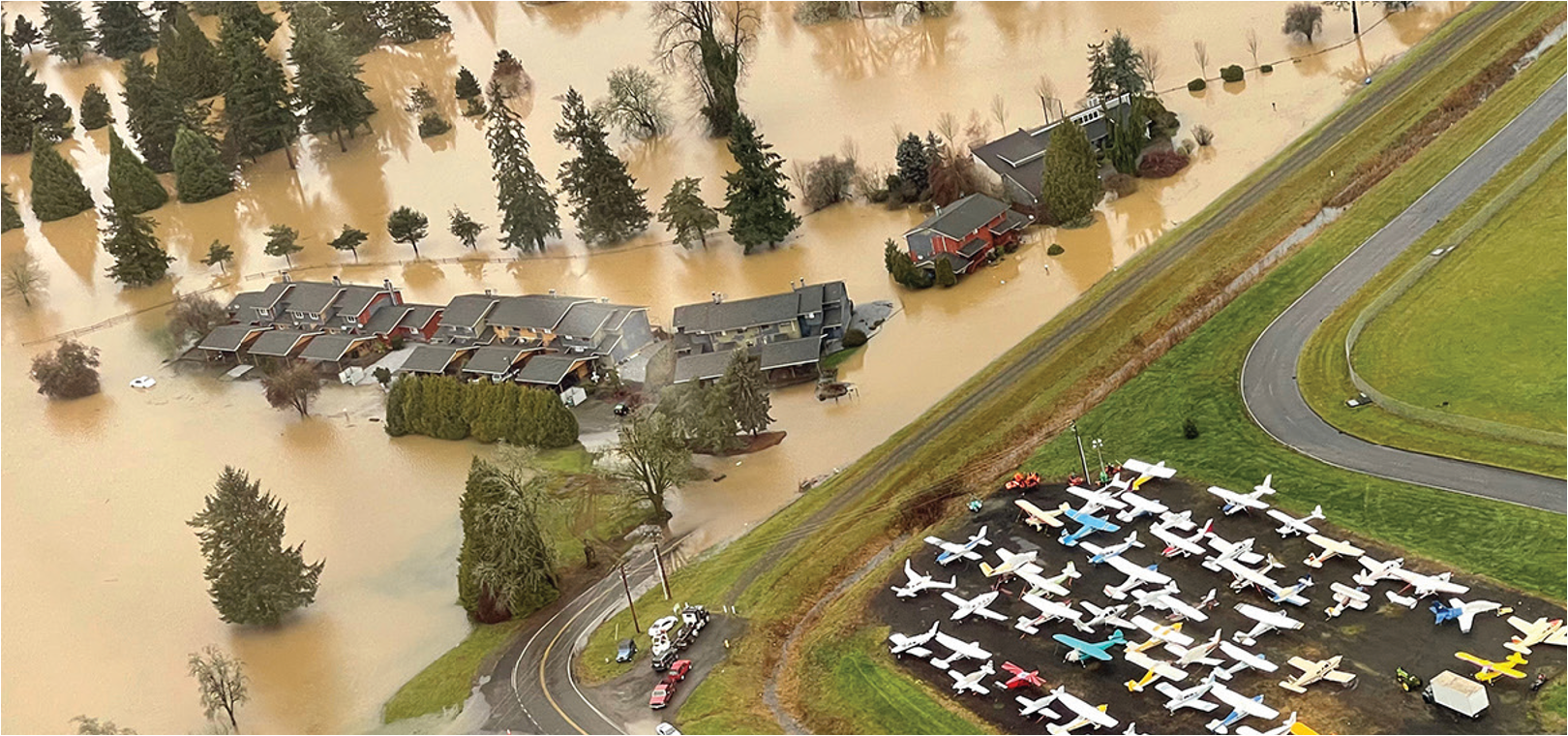
The proposed Safe Structures Program will offer flood damage protection for the estimated 1,625 existing valuable structures that might remain in danger of flooding, even with the investments proposed in the Preliminary LAND Alternative.
The proposed Safe Structures Program identifies strategies to prioritize and protect valuable structures (residences, schools, businesses, etc.) on an individual basis, without infrastructure such as levees, floodwalls and dams. The program will evaluate and prioritize actions for each of the “valuable” structures but not for “non-valuable” structures (garages, sheds, carports, etc.). While the Office of Chehalis Basin’s Community Flood Assistance and Resilience (CFAR) program is already performing many of the strategies of the proposed Safe Structures Program, it is not at the scale necessary to address the large number of valuable structures in need of flood damage reduction assistance.
The Safe Structures Program would include resources to assist low-income households (both renters and property owners) that are affected by flooding. Resources could take the form of funding assistance, low interest loans and technical assistance to help residents better understand their options for reducing their exposure to flood risk. Buildings behind FEMA-certified levees could reduce or eliminate their flood insurance; buildings in the Safe Structures Program would likely be paying similar rates to what they pay now.
Structure Risk Assessment
The approach to flood damage protection depends on the severity of risk, determining valuable structures that might be in harm’s way and where flooding poses a risk to life and human safety. Desktop evaluation has been done to get ballpark estimates, but on-the-ground evaluations will need to be done in the future to fully implement the program. Each structure will be evaluated using the following primary criteria:
LOCATION of structure on the property
DEPTH OF WATER above the lowest floor of the building
VELOCITY of water
REPETITIVE LOSS/FREQUENCY
where the structure has been identified as a repetitive loss property
COST EFFECTIVENESS
and if the mitigation measure exceeds the value or condition of the structure
Secondary criteria include whether the property is near other proposed large-scale infrastructure projects, is adjacent to public land, and on each community’s goals and preferences. The program includes five levels of flood damage protection.
Five-Level Mitigation Continuum
LEVEL 1: INSURANCE
Require flood insurance through the National Flood Insurance Program to property owners, renters, and businesses.
Level 2: RELOCATE UTILITIES
Elevate utilities—including furnaces, air conditioners, appliances, electrical and plumbing systems—above the flood elevation.
Wet floodproofing allows water to enter an area such as a crawl space to equalize the pressure of water on the building due to the force of gravity.
LEVEL 3: FLOODPROOF
Floodproofing a structure mitigates, but doesn’t totally eliminate, flood damage. With dry floodproofing, the structure is made watertight and all opening are closed so that water that gets to the building cannot get inside. The building itself is the barrier to the floodwater.
LEVEL 4: RAISE
Structures in areas the might see more than 1 foot of floodwaters would be raised, using fill material on extended foundation walls, piers, posts, piles and columns.
LEVEL 5: RELOCATE
For homes that can’t be raised, property owners could voluntarily participate in a buy-out with fair compensation and relocation assistance. The structure could be demolished and the property owner purchase or construct a new home outside the floodplain. Or the house could be physically relocated outside the floodplain, depending on the home condition and property owner preference. A key element of this program is offering “replacement value” rather than “fair market value,” which can encourage greater voluntary participation.
Applying the Safe Structures Approach
Residential structures remaining in the floodplain have been assigned to flood mitigation levels 2-5, based on desktop evaluations. Residential risks will be confirmed and refined through individual on-site assessments before there is a final determination about appropriate mitigation. All commercial properties and agricultural buildings remaining in the floodplain are assigned to Levels 2-3.
Currently, structural risk is ranked by water level, to develop an order of magnitude determination about the number of structures that need specific mitigation and their potential costs. (It’s recommended that an additional 1-3 feet of freeboard be added to each mitigation measure to increase safety.)
Safe Structures Program: Approximately 1,640 Structures*
* Estimated total valuable structures that could participate the Safe Structures Program. Relocation means either physically moving a structure to an area outside the floodplain or demolishing the structure, with owners moving into another structure outside the floodplain. Note that some structures, such as commercial structures, agricultural structures, and slab on grade structures with inundation greater than one-foot and included in the Raise category in this figure would likely still fall in the Protect category because they cannot be raised.
Affected Structures
The number of structures affected by flooding will depend on the structural interventions constructed in the Chehalis Basin. Assuming all recommended structural interventions are constructed, the number of affected structures could be reduced by about half, with the Cities of Chehalis and Centralia seeing the most dramatic reductions.
| Location | Without Recommended LAND* | With Recommended LAND Interventions* |
|---|---|---|
| Lewis County | ||
| Centralia | 1,339 | 278 |
| Chehalis | 274 | 158 |
| Adna | 100 | 100 |
| Boistfort | 80 | 80 |
| Pe Ell | 21 | 21 |
| Thurston County | ||
| Rochester | 185 | 202 |
| Grays Harbor County | ||
| Elma | 168 | 173 |
| Oakville | 129 | 136 |
| Montesano | 70 | 70 |
| Satsop | 9 | 9 |
| Aberdeen | 4 | 4 |
| Cosmopolis | 1 | 1 |
| TOTAL | 2,380 | 1,231 |
*This assumes a 75% participation rate of willing property owners. For example, of the approximately1,640 valuable structures remaining in the floodplain with the recommended LAND structural projects,1,231 in total would become part of the Safe Structures Program. Adding the ring levee in Adna couldreduce the number of inundated structures; future modeling will determine the number of structuresaffected by the proposed interventions.
*Estimates of valuable structures are based on the WSE structure database that contains finished floorelevations for valuable structures only. Because updated data is not available for recent development,the dataset does not include all structures in the floodplain; estimates of valuable structures might below or missing for certain locations. It is possible that more structures than quantified in this table andin additional areas could qualify for Safe Structures interventions.
Relocation/Rental Assistance
Homeowners who choose to raise their homes will likely need temporary housing, while those that relocate will need moving expenses. Renters who are displaced will also need relocation expenses.
If the program is self-funded, relocation assistance can be provided based on the terms created by the agency in charge of the program. If federal or state funding is used, tenant assistance is available under the Federal Uniform Relocation Assistance and Real Property Acquisition Policies Act of 1920. That assistance can include advisory services to find a comparable home and complete paperwork, pay for moving expenses, and replacement house assistance for the occupant to rent or buy (via down payment assistance) a comparable home.
Rough Order of Magnitude Costs
| Home Utility Relocation/Floodproofing: | $20,000 |
| Commercial/Agricultural Floodproofing: | $30,000 |
| Structural Elevation: | $150,000 |
| Replacement Home: | $400,000 |
| Relocation/Rental Assistance: | 5% of Relocation Costs |
Rough Order of Magnitude Costs
Resiliency Programs
As climate change increases the intensity, frequency, and duration of major rain and snow events, the risks of living with a river will also increase. We cannot completely prevent damage caused by outsized weather events. But as we begin to adopt our flood prevention and management plans, we can also build our capacity to recover and thrive after flood events.
Community resilience—the sustained ability of a community to withstand, adapt to and recover from adversity—has both social and material components. A resilient community provides residents and businesses with a sense of safety, connectedness, self-sufficiency, collective efficacy and hope for the future. Cultivating these qualities in advance of a crisis improves the likelihood that Chehalis Basin communities will successfully remain in the area and rebuild during the months and years it might take to fully recover.
There are also practical skills and plans that can be implemented before a disaster to improve the community’s ability to remain self-sustaining. Educating Basin residents about flood risks and projected floodplain boundaries, emergency escape routes, refuge areas, and resources such as resilience hubs is crucial to equipping each family to prepare and execute an emergency plan when disaster strikes.
Ongoing programming that supports resiliency can also become a part of community life. Training programs for trade skills such as carpentry and welding, and survival skills such first aid, strengthen overall community resilience. These programs can be linked to existing school and education programs.
Each Basin community also needs a well-coordinated early warning system (such as an expanded Chehalis Basin Flood Authority early warning system), paired with a way to identify nearby evacuation routes and community resilience hubs. While the region has an existing alert system, expanding broadcast cell phone alerts and networks of communication will continue to be an effective means to distribute early warnings, especially for Basin residents who live in isolated settings.
Resiliency hubs are neighborhood centers—often managed by community members in partnership with local governments—equipped to support residents, coordinate communication, and distribute resources before, during and after a crisis. They’re typically located in an existing facility that’s on high ground or protected by levees, such as Adna High School, community centers, and places of worship.
Floodplain Management
A key goal is to respect the natural river: wherever feasible, actions will recreate natural floodplains to restore natural geomorphic river flows and increase natural floodplain water storage capacity.
Floodplain management actions can include floodplain storage as well as smaller berms and floodwalls (under 6 feet). They remove human-caused barriers to water flow such as undersized culverts, and reconnects off-channel floodplain channels and side channels. All actions will be coordinated with the Aquatic Species Restoration Plan’s goal to restore about 5,000 acres of floodplain.
Potential Restoration and Recreation Opportunities
Image showing existing floodplain
Image showing floodplain after restoration is complete
Image showing floodplain restoration during flood event
First Image: Floodplain – existing
Second image: Floodplain after restoration is complete
Third image: Floodplain restoration during a flood event
Program Recommendations
CFAR and Safe Structures
- Require local jurisdictions to update flood maps to access Safe Structures funding
- Actively pursue grants and other funding to address the program scale and phasing
- Provide additional project management and technical assistance for landowners, renters and local jurisdictions to implement the program
- Prioritize areas where interventions are not proposed and that flood repeatedly
- Include programs for renters to secure new housing
- Include measures for both commercial and residential structures
Expanding CFAR or replacing with a Safe Structures Program is needed regardless of what future flood intervention measures are implemented.
Resiliency
- Organize a working group to develop an Upper Chehalis Basin Resiliency Plan to increase coordination and capacity to manage and maintain preparedness
- Update emergency access plans, including planning for livestock and machinery in rural areas (e.g. Adna High School accessibility and as a resiliency hub)
- Consider developing resiliency hubs in the region for long-term recovery that reflect urban and rural location needs
- Continue to expand early warning monitoring systems
Resiliency measures should be expanded and coordinated across the Basin, regardless of what future flood intervention measures are implemented.
ASRP/LAND Alignment
- Create an ASRP/LAND Working Group to identify potential synergies between the two programs
- Identify potential permit and regulatory streamlining opportunities to speed ASRP/LAND projects
- Focus LAND-related strategies on projects to reduce damage from smaller floods on agricultural uses
The ASRP does not include flood damage reduction in its goals, but much of what is recommended in the ASRP and LAND could provide economic, environmental and flood damage reduction value.