Approach
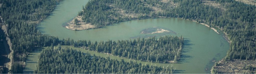
The Basin is the State’s second-largest river drainage system, made up of distinct landscapes: mountain foothills, farms, forests, small towns and cities. Its elevation ranges from sea level up to around 2,700 feet on its highest mountain. Important and rare species of fish and aquatic wildlife live in its wetlands, streams and rivers, it’s home to the greatest diversity of amphibians in the state, it offers crucial nesting grounds for migratory birds and a wildlife corridor connecting the Cascades to the Olympics and it’s one of the state’s most important wild salmon strongholds.
But it’s subject to increased flooding.
The goal is to develop flood damage reduction concepts that meet the needs of all communities in the Chehalis Basin. There are no preferred alternatives in place—we are soliciting input from community members and involve everyone in developing potential recommendations for credible alternatives to the proposed flood retention dam on the upper Chehalis River.
Change can involve difficult and sometimes painful discussions. Resiliency rests on a community’s ability to meet a challenge head on and adapt—while maintaining its identity.
Focus Areas
The Board has approved the primary and secondary focus areas for analysis for the LAND Alternatives process.
Primary Focus Area
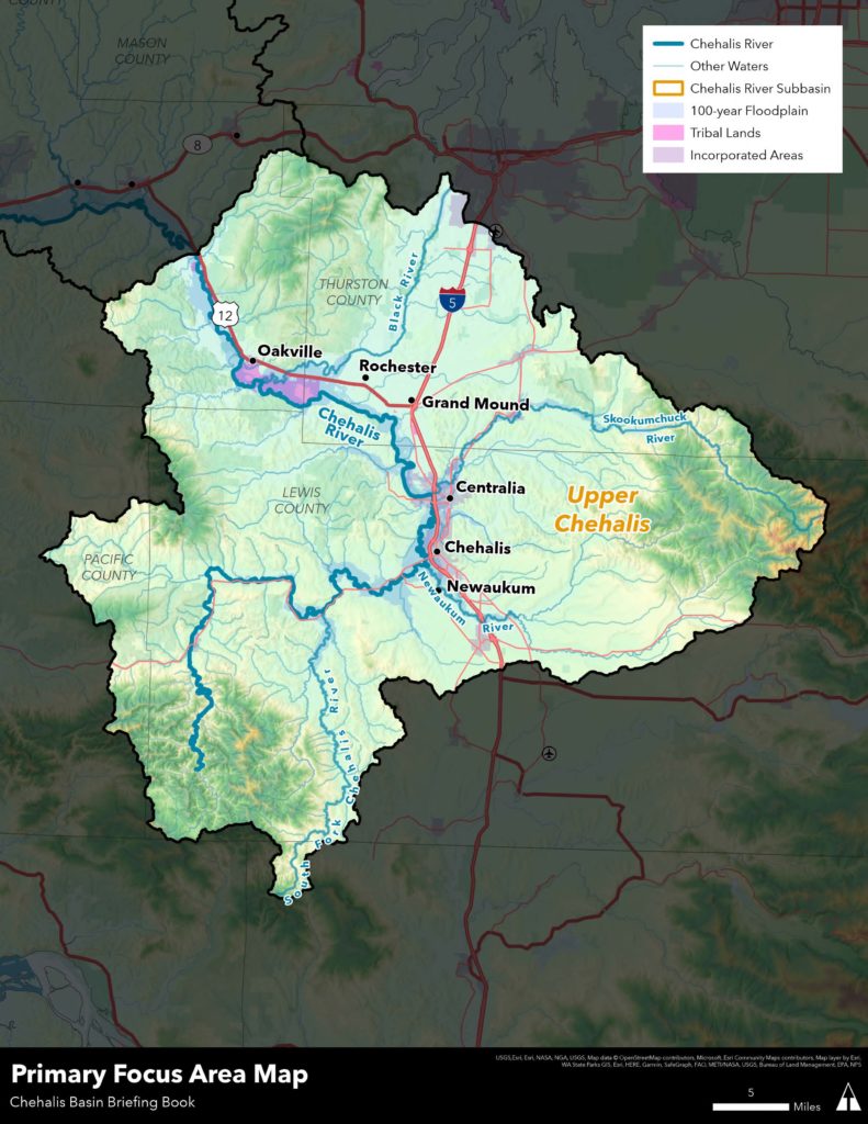
Current and future 100-year floodplain of the mainstem Chehalis River at and upstream of its confluence with the Skookumchuck River, including the current and future 100-year floodplains of the major tributaries to the mainstem in the upper basin: Skookumchuck, Newaukum and South Fork Chehalis Rivers.
Secondary Focus Area
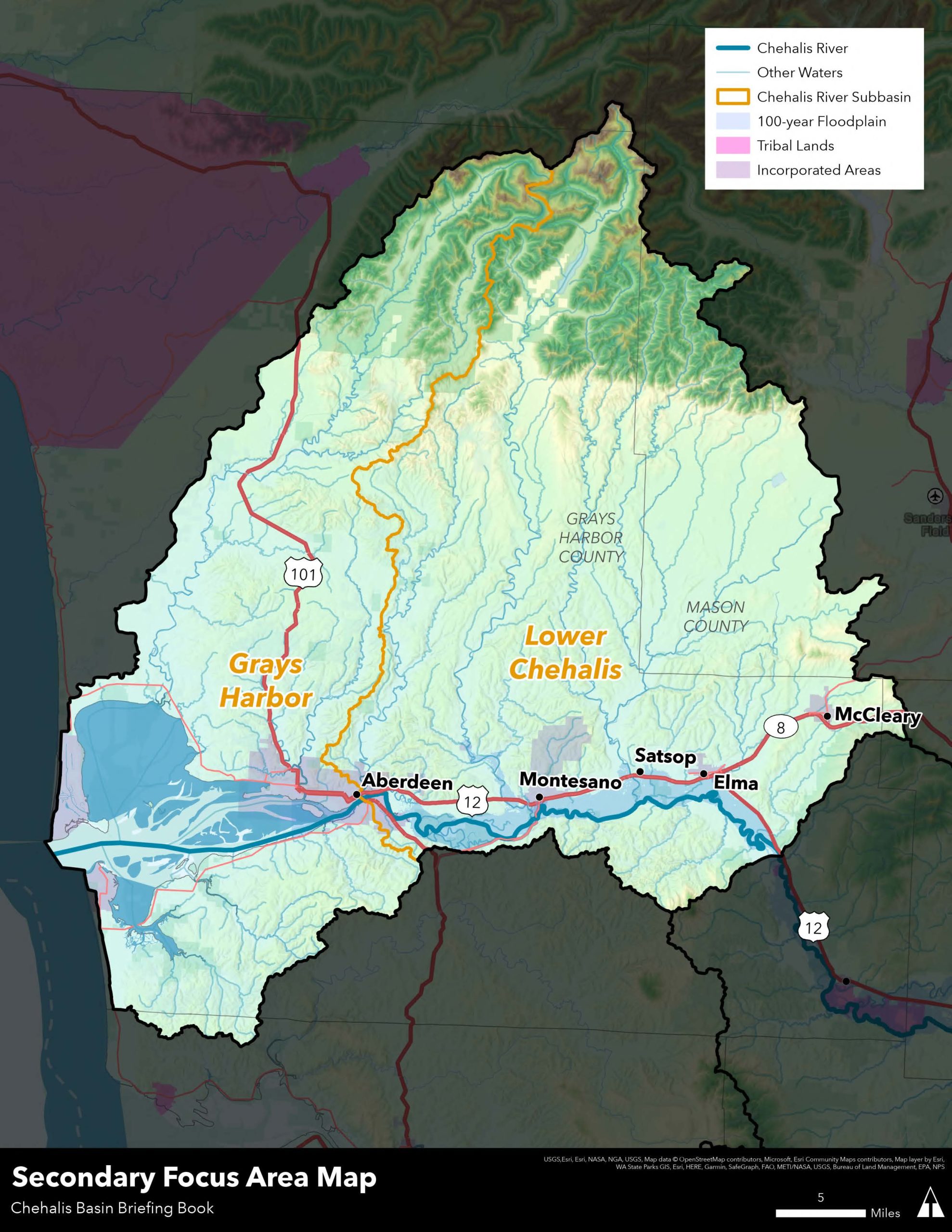
May include the current and future 100-year floodplains of the mainstem and major tributaries of the Chehalis River downstream of the Skookumchuck River, including the Black, Satsop, Wynoochee, Wishkah and Humptulips Rivers.
Preliminary Potential Outcomes
- Valuable Structures Protected from Mainstem, Catastrophic Flooding: The amount of existing homes, businesses and public buildings in the focus area that could be vulnerable to flood damage by current or 2080 predicted 100-year flood levels in the basin would be significantly reduced, because they are protected by localized infrastructure, flood-proofed/elevated, or the structure has been removed.
- Critical Facilities Protected: The amount of critical facilities in the focus area that could be vulnerable to flood damage by current or 2080 predicted 100-year flood levels would be significantly reduced, because they are protected by localized infrastructure, elevated/flood-proofed, or relocated.
- Farmland and Rural Structures Protected: The number of locations where migrating river channels and bank erosion pose a high risk of near-term damage to valuable structures or loss of economically productive land uses would be significantly reduced while protecting ecological processes.
- Environmental Justice Advanced: Communities with environmental justice concerns would suffer less hardship and damage from flooding, would not be disproportionately burdened by actions to reduce flood damage and would be improved by flood solutions.
Values Planning
The LAND SG invited community members and technical experts to come together and work with each other in a problem-solving environment to discover the values that tie us together as a community and to create solutions that address all of the issues.
Values Planning is a creative, participatory process that occurs in the early stages of a project before designers and engineers start their work. It considers a wide range of factors, including costs, risks, economics and economic development, long-term consequences, community benefits and environmental benefits.
The people involved include everyone—the owners, funders, planners and technical experts, operators and community stakeholders. In general, the purpose of Values Planning is to listen to the community, discover the real problem(s) that needs solving, discover alternatives for solving the problem and find consensus on the best approach to solving the problem.
Values Planning outcomes often reveal that many solutions can work if they are crafted to address a broad range of values, and it sets the stage for something new to emerge. It’s not a one-time meeting; it can and will happen throughout the project.
The Values Planning today will lay the groundwork for exploring alternatives, testing ideas and concepts, developing strategies and addressing concerns through an open, honest and inclusive series of dialogs.
POTENTIAL OUTCOMES
To provide possibilities for alternatives planning, the LAND SG developed potential outcomes that could be used to measure the success of LAND Alternatives, as compared to the dam, and what can feasibly be achieved within the timeframe of up to 30 years. These were developed from community stakeholder interviews and input from LAND SG members themselves, and do not identify precise targets for structures protected from flood damage.
Hydrology and Engineering
- Update and refine the hydrologic model to evaluate a variety of potential small and large non-structural solutions for the Basin for future flood conditions (2080) that can be compared to the Dam Alternative, as feasible.
- Develop and illustrate conceptual designs as educational and outreach tools for interventions that inform non-technical viewers the benefits of the solution.
- Create LAND Alternatives through landscape design and engineering interventions that balances flood damage reduction and impacts to development while also minimizing impacts to the natural environment.
Natural Environment
- Use a combination of scientific and traditional ecological knowledge to develop solutions for flood damage reduction.
- Ensure long-term viability of natural ecosystems while reducing flood damage.
- Minimize and/or mitigate potential negative impacts on local fish and wildlife populations.
- Identify and protect environmentally sensitive areas related to the LAND Alternatives.
Economic Development and Land Use
- Identify locations that can accommodate future development within urban areas that reduces the risk of sustaining flood damage.
- Identify and develop recommendations for voluntarily modifying structures that are at risk of flooding, either by raising, removing or relocating structures.
- Plan for future housing needs outside of flood-prone locations.
- Link recommended alternatives to existing programs and projects that protect current and create future job growth and economic development.
Urban/Landscape Design
- Develop LAND Alternatives that minimize flood impact to the urban environment.
- Identify existing and/or new programs to increase resiliency and recovery for all communities after a flood event has occurred.
- Identify potential land use and development policies that could be modified to reduce the impact of flooding within urbanized areas.
- Develop a flood protection plan that is phased and implementable over time.
Communications and Public Engagement
- Create a decision-making process that is transparent to the community.
- Collaborate with the Chehalis Tribes and Quinault Indian Nation to engage tribal leadership and its members.
- Collaborate with community members, landowners, businesses and other stakeholders to develop plans for the basin.
- Use both in-person and virtual outreach methods to solicit input from the broader community during the LAND Alternatives process.
- Identify areas of general consensus for LAND Alternatives.
- Create clear communications for the LAND Alternatives for the wider community to understand potential trade-offs and solutions.