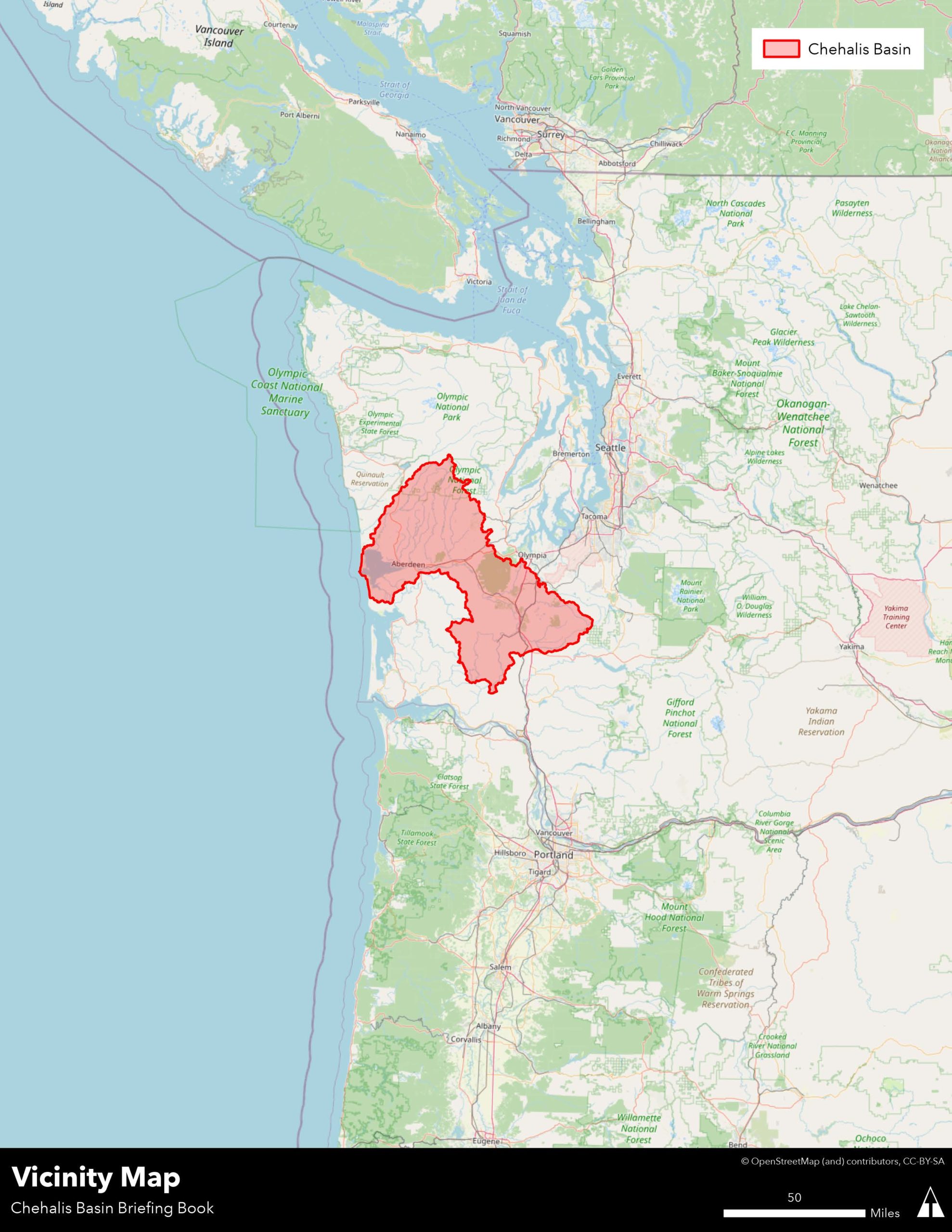
the chehalis basin
REGIONAL IMPORTANCE
Climate change
In aiming for a multi-benefit approach— balancing flood damage reduction, water supply, habitat and species conservation, recreation planning, and land use and economic development—the Chehalis Basin Strategy and the LAND Alternative offers an opportunity to work with nature, rather than attempting to tame it. Navigating diverse cultural, economic and ecological issues; juggling multiple objectives and stakeholder needs; and addressing the complex challenges of climate change make the Chehalis Basin a microcosm of challenges of the broader region.
The State of Washington prides itself on its commitment to green solutions and combating climate change. This Chehalis Basin comprehensive and inclusive approach can provide a template for other communities facing similar concerns.
Chehalis Basin Study Area
Transportation Corridors
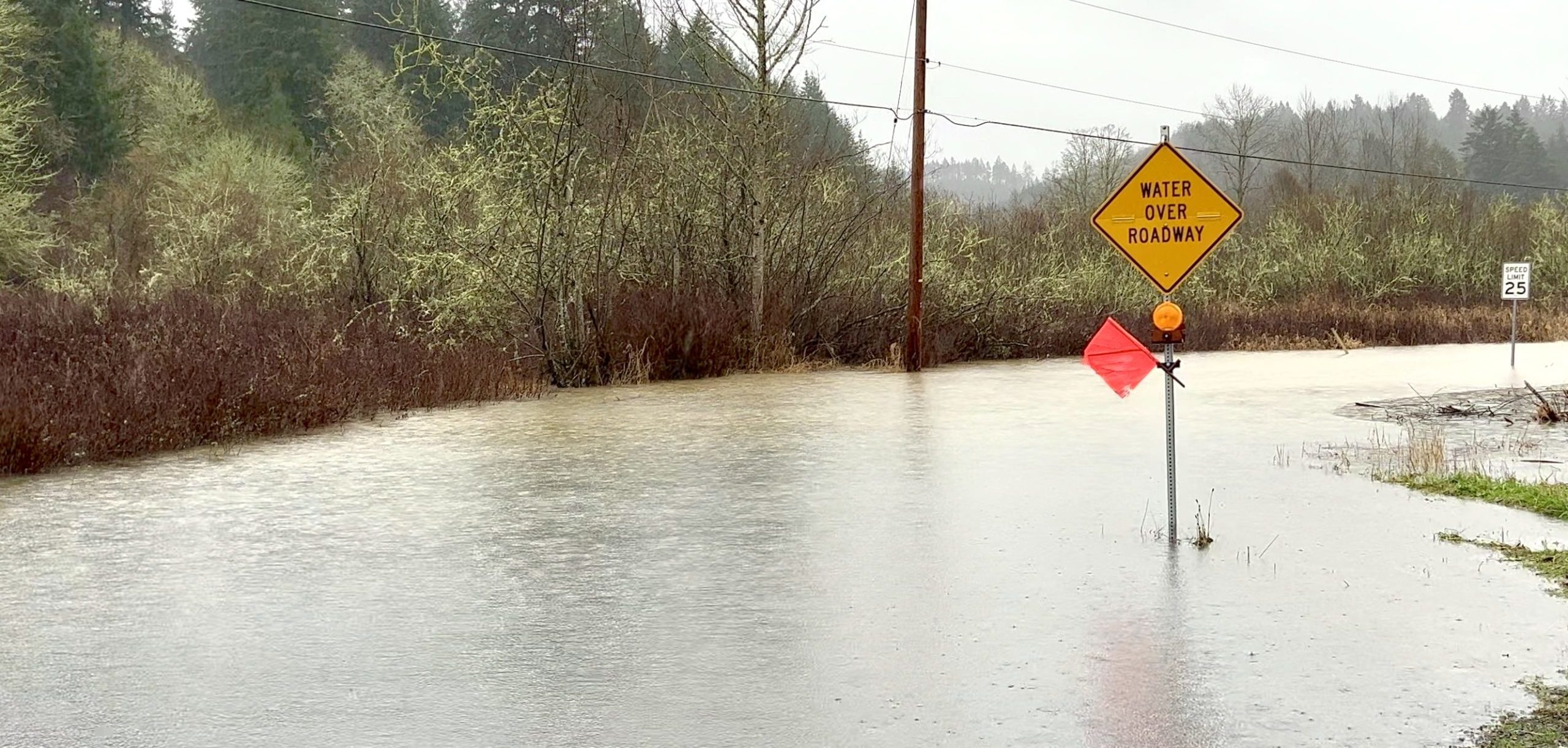
I-5 is the major north-south route along the West Coast, from Mexico all the way to Canada. When it’s closed, the entire West Coast feels an economic ripple effect.
I-5 was closed for four days in 1996 and again in 2007, two days in 2009 and several hours in 2022. Under current conditions, the Washington State Department of Transportation (WSDOT) predicts I-5 would be closed for as many as five days during a catastrophic flood in the Chehalis-Centralia area. A closure that long would drastically affect interstate commerce, as well as local access to critical medical facilities. And there’s no good detour because other local highways and streets will also be flooded or gridlocked with diverted traffic.
Past flooding has also affected State Route 6 and U.S. Route 12 (which provides regional access to the community of Rochester), as well as major roadways in Lewis, Thurston and Grays Harbor counties, the Centralia-Chehalis Airport and railroad facilities.
Aside from the cleanup and repair costs, the transportation delays cost businesses tens of millions of dollars each time I-5 is closed.
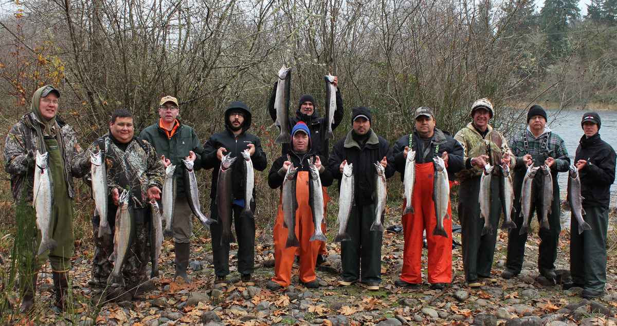
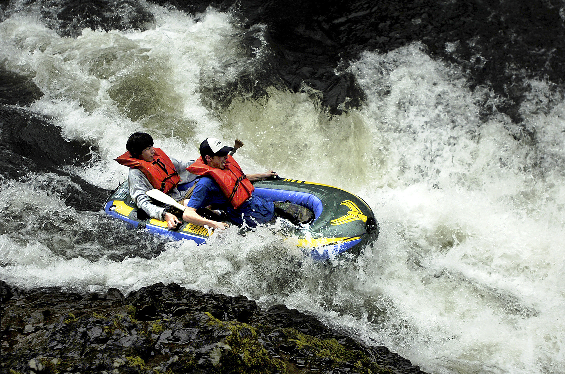
Recreation
Both Basin residents and visitors from Washington and Oregon enjoy the fishing, hiking, camping, birdwatching, kayaking and canoeing, whitewater rafting, hunting and golfing that the area offers. On the Chehalis River, three main facilities have experienced severe damage during flooding: Rainbow Falls State Park, the Southwest Washington Fairgrounds and the Willapa Hills State Park Trail. And others have experienced less severe flooding that can close and damage the facility. With continued flooding, more users would be affected by closures, which would also have an economic impact on communities like Chehalis, Centralia and Pe Ell.
ENVIRONMENTAL CONTEXT
The Chehalis Basin is about 2,700 square miles and is one of the largest river basins in Washington State. The geography of the Basin contains vast landscapes—from the upper reaches of the Chehalis River in forested, rolling hills, to fertile farmland and valleys, to the Pacific coast and marshlands.
Topography and Geology
Flooding has always been present in the Chehalis Basin due to its wide, flat topography. But as the climate changes, catastrophic floods are no longer isolated incidents, and 100-year floods now occur with increasing frequency.
The topography of the Chehalis Basin is quite varied, characterized by steep slopes at the headwaters, descending through progressively gentler slopes at the foothills and dominated by a relatively level valley floor. The steepest slopes are in the Willapa Hills and the southern Olympic Mountains. In the foothills, slope gradients are highly variable, from about 30% to 60%. In areas where tributary rivers and creeks enter the valley, the slopes are mostly gentle but may reach 10% gradient. The Chehalis River itself cuts through the valley sediment up to 30 feet, with near vertical slopes at the alluvial banks.
Historical GIS mapping of the Chehalis River shows relatively minor changes to its course over time, with a few key exceptions, including:
- A natural evolution toward greater meanders, particularly at the bend northwest of Millburn
- Transformation of the river’s topography, north of Pe Ell between Cannonball Creek and Shields Creek, after the 2007 flood
Rivers and Channels
The Chehalis Basin drains approximately 2,660 square miles of land in Lewis, Thurston, Grays Harbor, Pacific, Wahkiakum, Mason, Jefferson and Cowlitz counties to Grays Harbor at the Pacific Ocean near Aberdeen. The Chehalis River is the primary surface water feature in the area and flows over 125 miles from its headwaters in the Willapa Hills to Grays Harbor.
In the upper Chehalis Basin, the mainstem Chehalis River and the South Fork Chehalis River drain areas south and west of Chehalis and Centralia, including the Willapa Hills of the Coast Range. Major tributaries in the upper Chehalis Basin include the Newaukum and Skookumchuck rivers, which have headwaters in the Cascade Range foothills and enter the Chehalis River near Chehalis and Centralia, respectively.
The Chehalis River Watershed
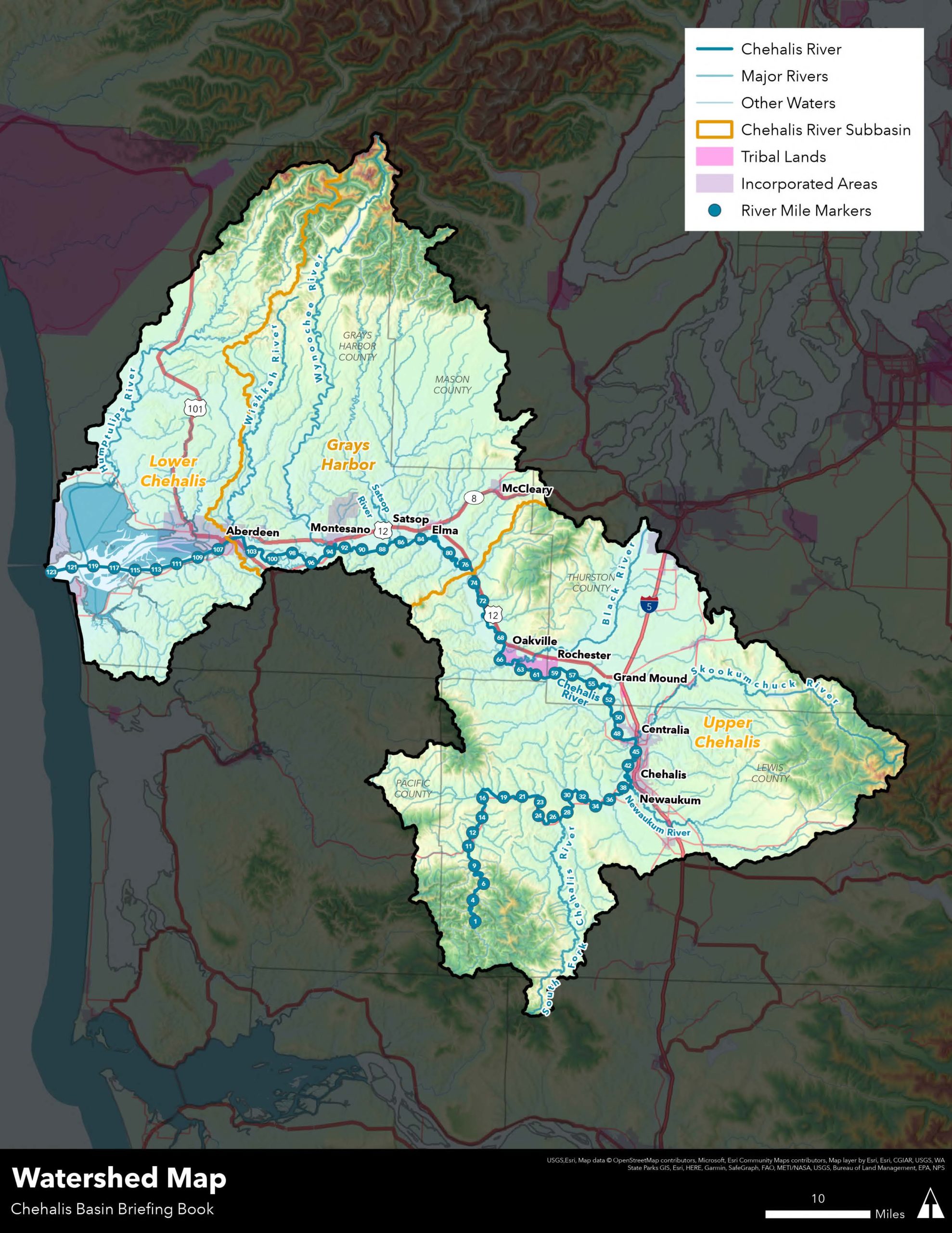
Another major tributary, the Black River, originates from Black Lake and enters the Chehalis River between Grand Mound and Porter by the Chehalis Reservation. The Satsop River meets the Chehalis River approximately 25 miles east of Gray’s Harbor, and the Wishkah and Hoquiam rivers join the Chehalis River by the harbor’s mouth at Aberdeen and Hoquiam, respectively.
Many smaller tributary streams also enter the Chehalis River along its course; among them are Alder Creek, Big Creek, Browns Creek, Crim Creek, Hull Creek, Lester Creek, Mahaffey Creek, Roger Creek and Smith Creek.
According to U.S. Geological Survey (USGS) data, Chehalis River flows are typically highest from November to February, and lowest from July to September. The following table shows median weekly flows at three USGS gages along the river—without a flood event.
Median Chehalis River Flows
| November– February | July– September |
|
|---|---|---|
| Doty | 400-1,000 cfs | 30-65 cfs |
| Grand Mound | 1,500-5,500 cfs | 210-430 cfs |
| Porter | 2,300-7,700 cfs | 390-630 cfs |
Fish and Wildlife
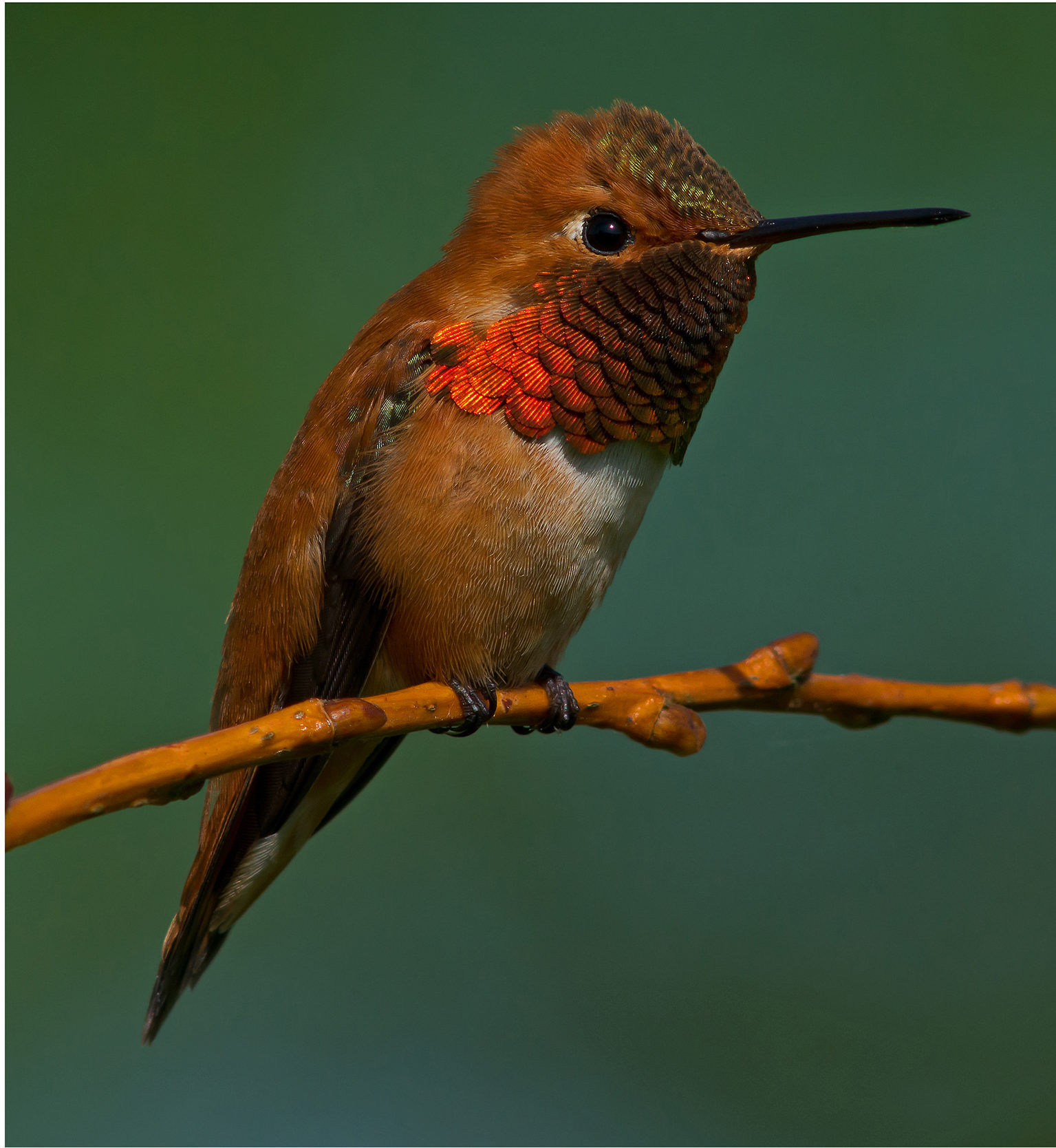
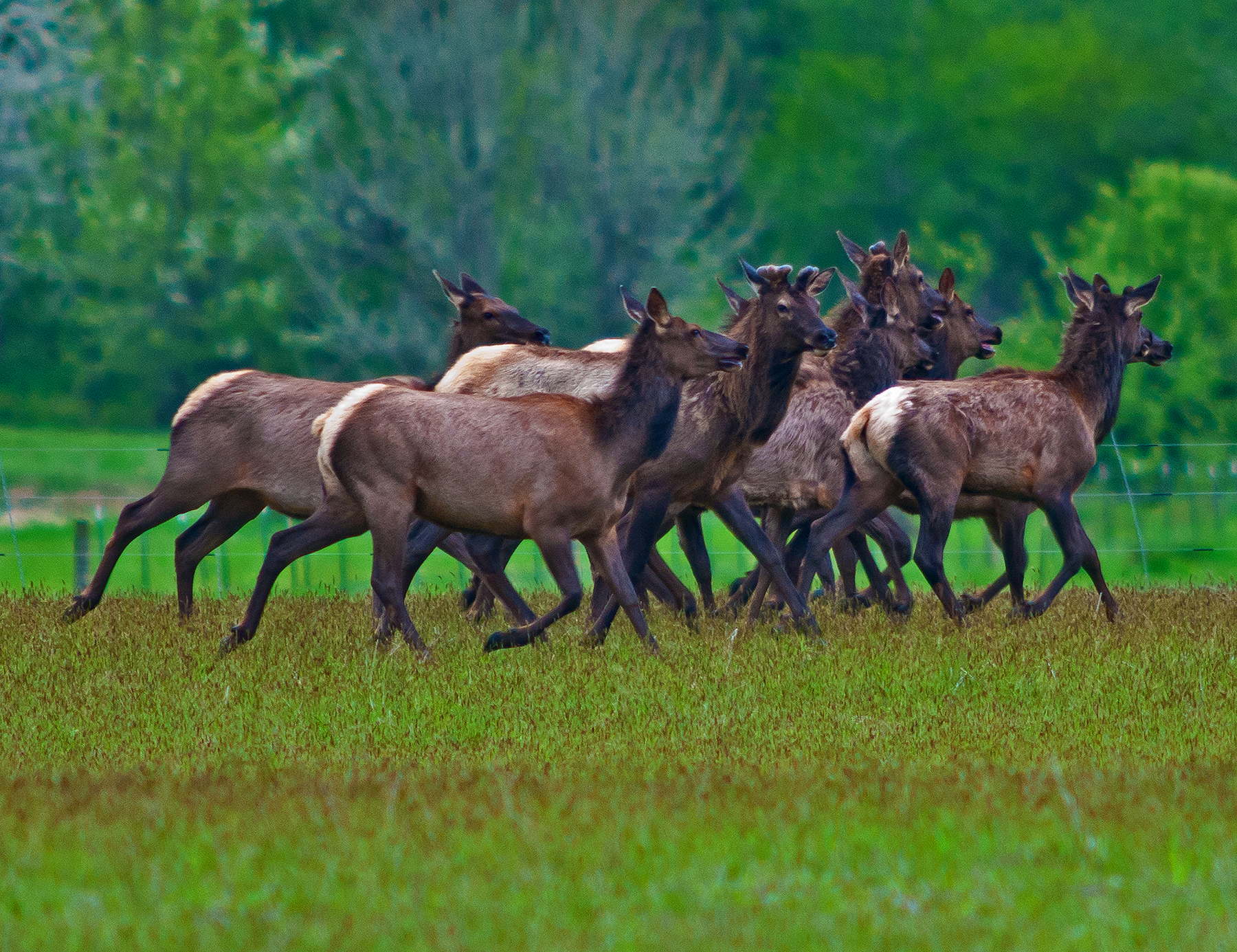
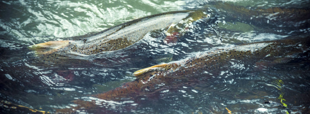
The Chehalis Basin is uniquely fertile with abundant wildlife. The Chehalis River and its tributaries are home to some of the most culturally and ecologically important species in the region, including steelhead, Chinook, coho and chum salmon. These waters also provide important habitats for lamprey and the largest array of amphibians in the state, including the Oregon spotted frog and the western pond turtle, both of which are listed as endangered or threatened species. Other endangered species include the marbled mullet, northern spotted owl, streaked horned lark and yellowbilled cuckoo.
The fish community in the upper Chehalis River and accessible tributaries consists primarily of Chinook salmon, coho salmon, steelhead and rainbow trout. The Chehalis River watershed is one of the state’s only major river drainage systems with no salmon species listed as threatened or endangered. But salmon runs have declined precipitously, due to a combination of lost and damaged habitat, changing climate conditions, and development. The basin’s ability to support some types of fish has been greatly diminished. If aquatic habitat in the basin does not improve, salmon, steelhead and other species could become endangered.
Scientists, researchers and technical specialists say if no action is taken in the basin, we could lose Chehalis River spring Chinook salmon entirely in 60 years. We could also lose a significant percent of the economically vital steelhead runs in that same period.
Source: Office of Chehalis Basin
Adult salmon and trout migrating to spawning habitats need barrier-free passage corridors with enough water depth and flow to provide unimpeded access to spawning areas. Spawning adults require specific flow conditions, cover and access to spawning gravels to deposit eggs.
Once deposited, fertilized eggs need to incubate in stable substrates that are free of excessive fine sediment and porous enough to allow oxygenated water to flow past the developing embryos. Juveniles emerging from spawning gravels need access to food, cover and space to rear. Eventually, juvenile salmon need adequate flows and barrier-free conditions to migrate downstream to marine habitats. While residing in freshwater during summer months, juvenile salmon and trout actively migrate upstream and downstream relatively short distances, usually less than one mile, but in some cases several miles.
In addition to the robust fish population, the Chehalis Basin is also home to shellfish (mussels) and a variety of macroinvertebrates such as snails, crayfish, aquatic worms and other species. These creatures are vulnerable to rapidly changing aquatic conditions. When flooding overwhelms sewage systems and releases contaminants into the water, the exposure can be harmful to fish and other aquatic species.
Flood damage reduction projects will need to consider the potential impacts on fish and wildlife, both short term and over time, and evaluated in concert with the Aquatic Species Restoration Plan.
Weather Systems and Impacts
As the climate changes, catastrophic floods in the Basin are no longer isolated incidents, and 100-year floods are occurring with greater frequency—the most recent happening in January 2022.
Storm surges and weather cycles of increasing intensity will continue to deluge communities like Chehalis and Centralia, as well as Aberdeen, Hoquiam and others, causing millions of dollars in property damage and disrupting transportation routes along I-5 and other key arterials.
Due to climate change, the trend of larger, more frequent winter flooding events will continue. Climate change is bringing more frequent and intense fall and winter storms. Heavy rainfall is often associated with “atmospheric river” weather systems. Atmospheric rivers, or “pineapple express” systems (because they come from the southwest and Hawaii, rather than from the north), carry bands of concentrated warm, low-level moisture from the tropics, producing heavy rain when they encounter the mountain ranges and cooler air of the western U.S. Rainfall from such systems has led to major flooding in the Chehalis Basin with the heaviest precipitation in the basin typically falling in the Willapa Hills, Cascade Range foothills and Black Hills.
Summers are becoming hotter and drier, with droughts becoming more frequent in the basin. With climate change, the trend of lower summer water levels in rivers and streams will continue. That can create more frequent lowwater events as stream flows decrease, which can affect both fish and aquatic species due to higher water temperatures, loss of habitat and lower oxygen levels.
Landslides
Landslides are common in the Chehalis Basin during high-intensity storms when rain—often in combination with melting snow (rain-onsnow events)—saturates surface soil layers or contributes to streamflow, which can undercut the toes of adjacent landslide areas.
Within the Chehalis Basin, landslides occur in the Willapa Hills, the Cascade Range and the Olympic Mountains. Landslides are commonly triggered by above-average precipitation and/ or undercutting of a slope, but they can beexacerbated by human activities such as clearing vegetation and building roads. More than 1,000 landslides occurred during the 2007 storm. After the 2022 storm, the Quinault Nation declared a landslide emergency.
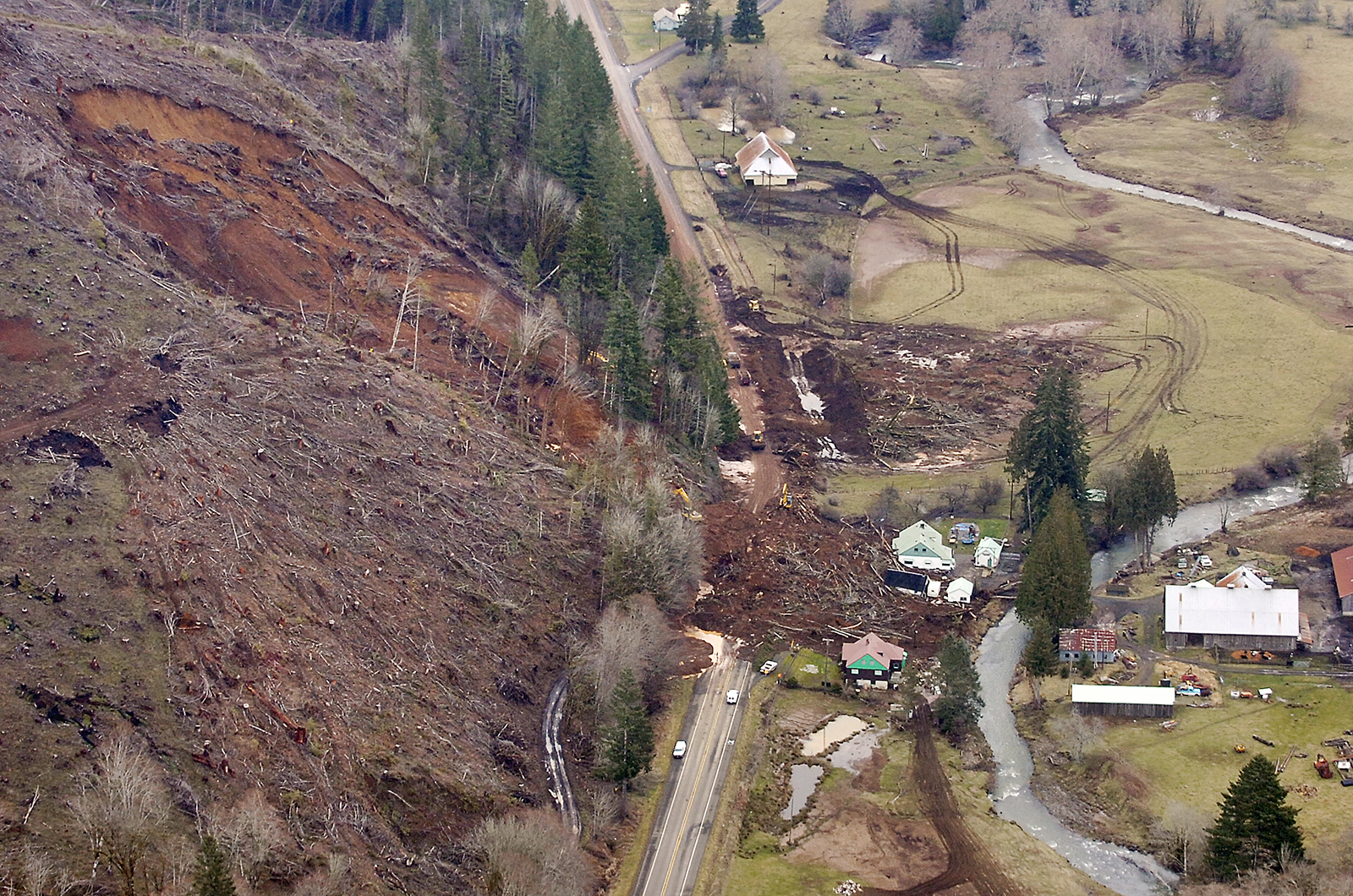
Three categories of landslides tend to occur in the Chehalis Basin:
- Deep-seated
The largest of the three landslide types, deep-seated landslides are slow moving, deeper than tree-root depth (i.e., 6-10 feet) and tend to occur as the cumulative effect of longer-term wet periods, such as multiple years of above-average rainfall, rather than single storms. Deep-seated landslides can last for many years. - Shallow
Shallow landslides are generally less than 10 feet deep, within the forest root zone, and are often the result of bursts of intense rainfall following periods of long saturation. Sudden downpours can loosen soil and trigger the slide. In certain instances (e.g., on steeper slopes) shallow landslides can mobilize as debris flows. - Debris flows
Debris flows usually begin on steep slopes but can travel greater distances over gentler ground depending on how much solid debris it carries compared to the water volume. Debris flows can range from wet mudflows to slurries of water and rubble with a mixture similar to wet concrete.
THE INDIGENOUS STORY
Source: Larry Workman, Quinault Indian Nation Communications Manager
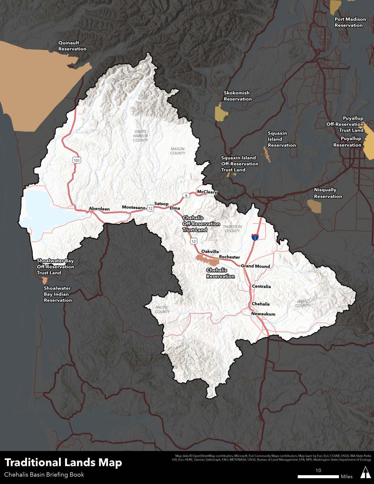
What we call the Chehalis Basin today makes up the ancestral lands of numerous tribes. Two sovereign nations currently exist within the Basin—the Confederated Tribes of the Chehalis Reservation and the Quinault Indian Nation, which has treaty rights to fish, hunt and gather in the Chehalis Basin.
Both the Quinault and the Chehalis people are inseparably linked with the watershed—where they have stewarded salmon, steelhead and other species and the habitat upon which they depend—for thousands of years.
“The Chehalis Tribe and Quinault Indian Nation have participated and supported the Strategy since its inception because of its inclusive, collaborative, and science-based approach.”
– Chehalis Basin Board members Tyson Johnston, Vice-President, Quinault Indian Nation, and Harry Pickernell Sr., Chairman, Confederated Tribes of the Chehalis Reservation
Traditional Lands
Flooding
Major flood events have had significant impacts on tribal lands and resources. In 2022, a King Tide in Gray’s Harbor overtopped the seawall protecting the QIN’s main village of Taholah, inundating the lower village for several days. The increasing frequency and severity of these types of events, and the threat of tsunamis, have led the QIN to create a master plan to relocate the village to higher ground and to develop green and resilient infrastructure systems.
Flooding in the Chehalis Basin also isolates portions of the Chehalis Reservation, cuts off access to basic goods and services, and threatens water and wastewater infrastructure.
Recent floods requiring evacuation or sheltering-in-place have disrupted public services, closed schools and taken a major toll on local businesses.
However, both the QIN and the Chehalis Tribe believe that a dam would irrevocably damage the sacred and essential resources of the river. They seek an inclusive, collaborative and science-based approach to addressing the impacts of flooding while improving natural species habitat.
ECONOMIES OF THE BASIN
The 2,700-square mile Chehalis River Basin is unique mosaic of distinct economic communities: farmers, foresters, commercial and recreational fishers and all the communitybased supporting business and services. Highly productive soils along with high annual rainfall support agriculture and excellent tree growth throughout the watershed. Wetlands and streams support abundant shellfish and one of the state’s most important wild salmon areas.
Since the mid-1800s the area’s fertile valleys, lush forests, and abundant fisheries have drawn in both US citizens and immigrants from around the world, eager to improve their lives.
The last 150 years of human development have not been kind to the Chehalis Basin. Previous destructive logging practices, farming operations and flood control measures have severely altered the natural operations of this dynamic ecosystem, which has dramatically diminished the basin’s ability to mitigate major flood events and maintain vibrant salmon populations.
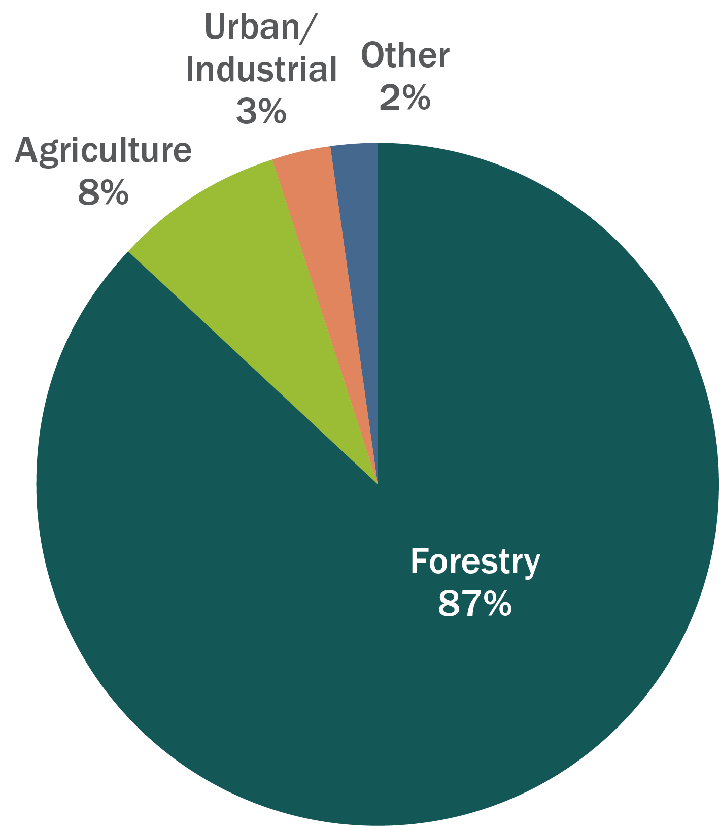
Percentage of Basin Lands
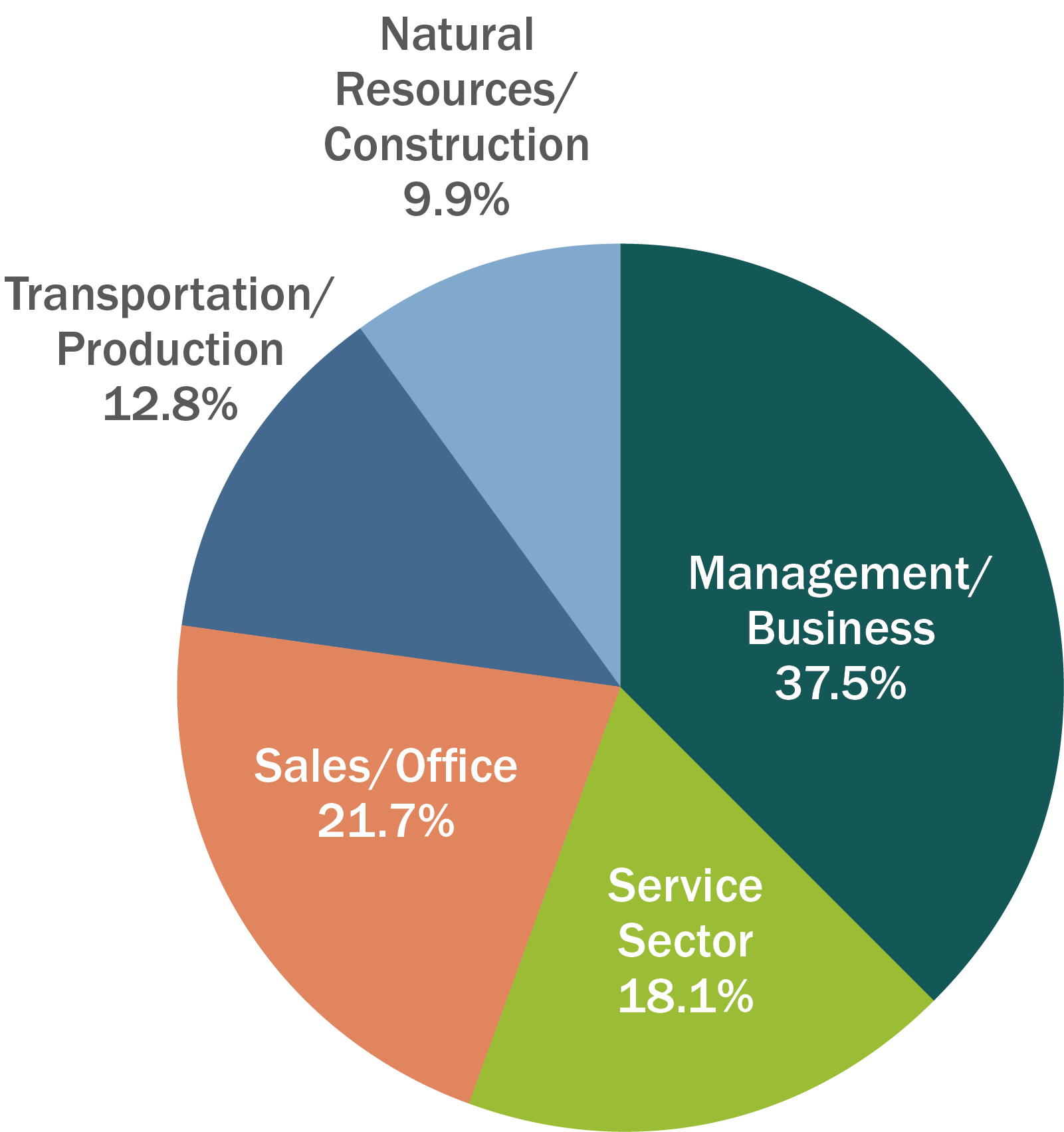
Employment
Most Basin residents are now employed in the management and services industries, unlike historical highs percentages of people employed in the timber industry.
In Grays Harbor County, the average annual unemployment rate had been on a decline year over year since 2010, when it reached 13.9%. In December 2021, it was 5.5%. Major employers include Stafford Creek Corrections Center, which employs close to 600 staff, and the Quinault Nation, which estimates it generates nearly 1,400 direct and indirect jobs. Charter fishing and ocean beaches continue to bring in tourists. The Port of Grays Harbor continues to expand its lines of business including increased log exports, a new compressed natural gas (CNG) facility, and a proposed crude oil facility.
In Lewis County, average annual unemployment had also been declining since a high of 13.3% in 2009. The pandemic led to a sharp increase, but the rate has been coming down again and was 6.6% in December 2021. Compared with other Washington counties, Lewis has a very high number of people employed in farming, fishing and forestry. The Chehalis Tribe employs about 1,500 people in its hospitality businesses.
Employed Population in the Basin
Timber and LoggiNg
Along with their commercial value, trees like the western red cedar used in making canoes and paddles, baskets, hats, split boards for houses, as well as in prayer and ceremony, have deep cultural values for northwest coast peoples. Trees also provide nursery and habitat for wildlife, and they play an integral role in capturing pollutants from the water and air and removing carbon from the atmosphere.
The timber industry has played, and continues to play, a huge role in the basin’s economy. The dense forests of cedar along with spruce, hemlock and Douglas fir attracted large numbers of loggers and mill operators in the late 1800s and early 1900s, eager to harvest as much as they could, as quickly as they could, clear cutting old growth forests.
In 1880, a water-powered grist mill at Cosmopolis was converted to a sawmill and the following year, Grays Harbor’s first load of lumber was shipped to the world. Clearing the Chehalis River later in the 1880s meant that steamers could reach Montesano from Grays Harbor and, during high water, go all the way up to the rail connection at Chehalis. Workers and equipment could be brought in; logs and finished lumber could be shipped downriver to Grays Harbor or east by rail. At the same time, new technology—the new geared-locomotive for steep grades and the donkey-engine to move logs—provided access to immense stands of trees that soon fell to the crosscut saw.
In 1885, mills opened at Hoquiam and Aberdeen. And by 1890, over 36 mills filled 256 ships with 66 million board feet of cut lumber out of Grays Harbor. Meanwhile, the railroad had also come from Puget Sound as far west as Elma and Montesano, to haul logs and goods in the other direction. But it was the rail connection from Aberdeen to Montesano that promised to be the key to wealth and prosperity. Residents of Aberdeen built that track themselves, using rail salvaged from a shipwreck, ties contributed by local mills, volunteer labor, and donated building lots. The first train arrived in Abderdeen in 1895 and in Hoquiam shortly after. Loggers then had access to three transcontinental railroads for transporting timber products, in addition to the ships.
With mills and shipyards buzzing along the shore and steam whistles screeching in the woods, the logging industry boomed and immigrants from all over the world flocked to jobs offering cash wages. But working and living conditions were pretty awful and contentious unionizing continued for decades.
In the 1920s, the wood-products industry— logging, milling and pulp manufacture—started a long, slow decline. Most timber was cut from private land and, once property was logged off, it was often abandoned. As the old-growth trees were used up, logging companies and the mills gradually closed. And the collapse of the US housing industry during the Great Depression (1929-1939) left more mills silent.
OLD GROWTH VS. NEW GROWTH
Forest ecosystems provide a wide range of benefits to the Chehalis Basin. But not all forested lands provide the same benefits. A recently cut and planted area doesn’t prevent flooding or provide water filtration or recreational values in the way that a mature or an old growth forest does. Unsustainable logging practices lead to soil erosion that sends sediment into streams, habitat fragmentation, as well as fewer species of trees, plants and the animals that the habitat sustains. This can also make forests more susceptible to extreme weather incidents and disease.
Seeing the end of old-growth harvests, Weyerhaeuser opened its first tree farm near Montesano in 1941. Congress passed the Forest Practices Act in 1946, which hoped for a sustained yield by managing the harvesting of national forests while also replanting private lands. While there was still demand for timber, cheaper overseas labor and automation meant that by 1975 as much as 40% of Washington’s wood-processing capacity was shut down.
Then came the Northwest Spotted Owl controversy. In the 1980s, federal officials started limiting the sale of trees from public land to protect the owl and in the 1990s protections were extended to private lands. The amount of timber cut from public land fell to less than 25% of its past levels. When the government listed salmon as a threatened species in 1999, that further limited areas that can be logged.
Today, 87% of land in the Chehalis basin is in lawfully permitted forestry. Much of it is in private ownership and managed by major commercial/industrial timber companies, but there are many smaller family-scale forestry operations as well. Even so, the effects of current, lawfully permitted, forest practices are often pointed to as a significant contributor to floods and landslides.
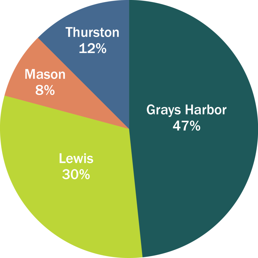
In 2017, Lewis County produced the highest volume of timber within the study area, followed by Grays Harbor County (note these numbers are for the entire county, not just the portion of the county within the Basin). The majority of timber produced in each county in 2017 came from private land.
CHEHALIS BASIN LANDSCAPE SCALE RESTORATION PROJECT
A US Forest Service-funded project implemented by Washington State Department of Natural Resources, the Washington State University Extension and the Grays Harbor Conservation District, aims to increase the number of sustainably managed family forests using written forest stewardship management plans, and tie individual landowner objectives to landscape-scale resource management objectives. Many family forests in the Basin now follow sustainable forest plans.
Timber Production by County, 2017
| Grays Harbor County | Lewis County | Pacific County | Thurston County |
|
|---|---|---|---|---|
| Total Harvested (board feet) | 311,600,000 | 370,977,000 | 176,167,000 | 78,510,000 |
| Private/public ownership (volume) | 86%/14% | 87%/13% | 86%/14% | 75%/25% |
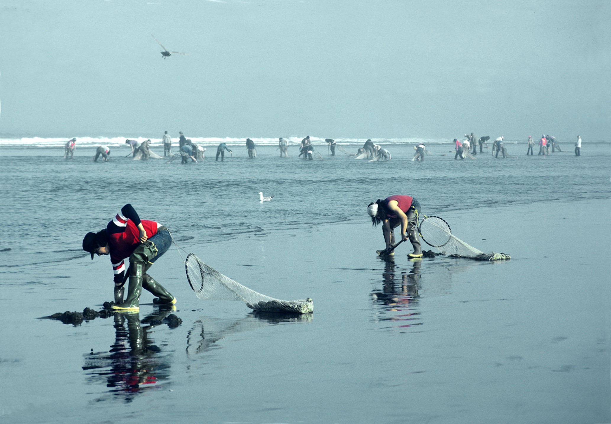
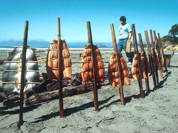
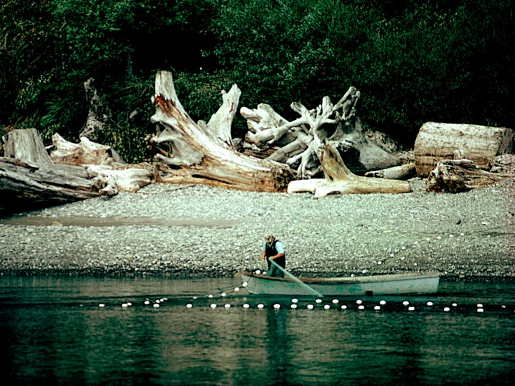
Fisheries
Fishing and shellfishing are a core part of the Basin’s identity, both in terms of economic sectors (tribal and non-tribal commercial fishing industries and sport fishing) and for their cultural significance for tribes and non-tribal fishers. Also important are freshwater aquatic macroinvertebrates that fish feed on and fisheating birds that rely on sufficient fish being available.
The Chehalis River Basin is one of the few major river basins in Washington with no federally listed endangered salmon. And it has the highest diversity of amphibian species in the state. The Basin supports Chinook, coho and chum salmon, steelhead and other trout, the Pacific Lamprey and the Olympic mudminnow, in addition to shellfish such as razor clams and freshwater mussels. The salmon, steelhead and Pacific lamprey spend their lives migrating through the freshwater tributary rivers, to the Grays Harbor saltwater estuary and the ocean. And the watershed still retains some connectivity with its floodplain, an essential component for the life cycles of many aquatic species.
The estuary area at the mouth of the Chehalis historically held vast eelgrass beds and vegetative species such as beargrass that are also important tribal resources. About 70% of the estuary is still intact, with most of the loss resulting from damage caused by land conversion. Today, eelgrass beds still provide nurseries for crab, shellfish and finfish.
All the waterways are regulated by a large number of federal, state and local laws, acts and codes. However, for decades, development, land use management and forest practices across the Basin have led to degradation of forest, floodplain and riparian habitat throughout the watershed. Agriculture, logging, gravel mining, dredging, dams, water diversions, transportation infrastructure and pollution have all had a negative effect on the habitat. And water temperatures throughout the Chehalis River are relatively warm due to its low elevation—and due to the loss of shade that was historically provided by mature riparian vegetation. The water frequently exceeds maximum temperature thresholds in summer for both salmon and steelhead.
Estimates show that habitat for salmon production has been reduced by as much as 80-87% from historic levels. And that existing salmon populations are now less than 50% of their historic run sizes, with spring Chinook salmon currently just 23% of historic run sizes in the Chehalis Basin overall.
Other estimates are even worse. Recent modeling by fisheries biologist Larry Lestelle shows salmon declines in the Upper Chehalis as high as 97.9% for spring Chinook, highly prized by the Quinault people as the first salmon species to return to the rivers in the spring. His modeling also shows salmon in the Upper Chehalis River are down 92.4% for coho, 81.4% for fall Chinook and 76.7% for steelhead.
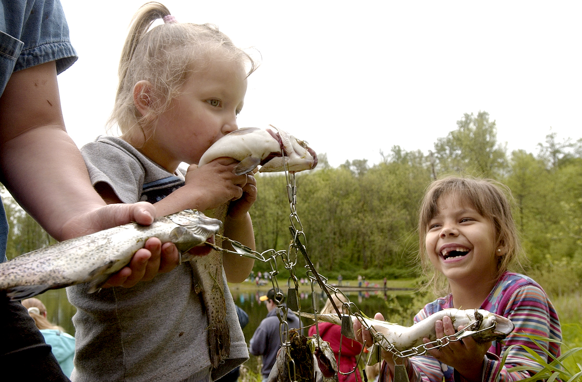
THE VALUE OF A FISH
One salmon can be worth as much as $2,400! The price a fisher can sell a fish for ranges from $5 to $48, depending on the species (in 2016 dollars—it’s more now, of course). The value of a sport fish can be up to $165, including the value of the fish and the experience of fishing, and whether it’s ocean or river fishing. And even those who don’t fish themselves enjoy the existence of wild salmon populations to the tune of $2,232 per salmon (based on how much people in the State of Washington are willing to pay for maintaining wild fish).
Source: Chehalis Basin Economic Study, 2016
Source: Larry Workman, Quinault Indian Nation Communications Manager
Economic Value Per Fish, 2016 Dollars
| Species | Chinook Salmon | Coho Salmon | Chum Salmon | Steelhead |
|---|---|---|---|---|
| Ocean Commercial | $48 | $10 | $5 | N/A |
| Ocean Sport | $86 | $53 | N/A | N/A |
| Grays Harbor Commercial | $51 | $10 | N/A | N/A |
| Grays Harbor Sport | $104 | $65 | $32 | N/A |
| River Sport | $165 | $147 | $73 | $94 |
| Tribal Commercial | $26 | $10 | N/A | N/A |
| Passive Use Value | $2,232 | $2,232 | $2,232 | $2,232 |
In most years, both tribal and non-tribal fishers have had to limit, or forego entirely, harvests to protect the most vulnerable species. In the future, Upper Basin salmon and steelhead populations are predicted to drop 70% more from current levels without aggressive protection and restoration. And from Rainbow Falls to Crim Creek, spring-run Chinook, coho, and steelhead could disappear entirely by late-century.
AVID SALMON FISHERS
Although the catch record cards submitted in 2016 don’t show where the fish were caught, they do highlight that a large percentage of residents in Lewis and Grays Habor counties recreationally fish for salmon.
| Lewis County | Grays Harbor County | |
|---|---|---|
| Total Cards Submitted | 10,273 | 9,857 |
| % of Population Submitting Cards | 13.3% | 13.8% |
| Freshwater Salmon | 8,634 | 4,726 |
| Marine Salmon | 1,827 | 2,161 |
Value of Ecosystem Services
| Low | High | ||||
|---|---|---|---|---|---|
| Total Value ($/acre/yr) | Total Value ($/acre/yr) | ||||
| Land Cover Class | Acres | Min | Max | Min | Max |
| Beach | 181 | $4,505,274 | $19,842,969 | $4,735,897 | $21,095,890 |
| Estuary | 59,989 | $49,603,557 | $974,290,768 | $54,723,527 | $1,149,545,636 |
| Rivers & Lakes | 12,349 | $21,786,729 | $262,518,378 | $25,637,921 | $295,506,680 |
| Wetlands | 89,636 | $381,682,803 | $5,414,576,450 | $393,290,761 | $5,673,477,518 |
| Cropland | 14,967 | $14,349,924 | $39,035,710 | $14,893,373 | $40,382,763 |
| Forests | 887,280 | $539,136,435 | $7,163,780,868 | $588,927,586 | $7,854,730,675 |
| Grasslands | 136,598 | $35,801,102 | $259,654,299 | $36,982,090 | $269,690,666 |
| Pasture | 79,036 | $11,243,799 | $39,713,808 | $12,806,181 | $43,758,074 |
| Scrub/Shrub | 353,956 | $54,596,872 | $189,616,631 | $68,089,678 | $231,010,531 |
| Urban Green Space | 13,335 | $27,677,747 | $90,223,491 | $30,203,713 | $98,725,619 |
| Total | 1,647,328 | $1,140,384,242 | $14,453,253,371 | $1,230,290,727 | $15,677,924,052 |
Source: Larry Workman, Quinault Indian Nation Communications Manager
The Draft Environmental Impact Statement, prepared by the Washington Department of Ecology, found that construction of the dam would affect spring-run and fall-run Chinook salmon, coho salmon, steelhead, other native fish like lamprey, as well as shellfish and aquatic macroinvertebrates. The construction itself would reduce fish passage around and through the dam, and vegetation and tree removal in the temporary reservoir inundation area would have a combined effect across more than 100 miles of the river and its floodplain, extending from about six miles upstream of the proposed dam down to RM 9, west of Montesano—where the effects on fish would be most noticeable. Marine mammals and fish-eating birds would be indirectly affected because of the reduction in fish. However, raised airport levees would have only minimal direct impacts on fish and fish habitat because the levees would be above the ordinary highwater mark.
Without the dam (some already approved large- and small-scale efforts would continue), aquatic habitats and species will continue to be affected by increased flooding and climate change. This would reduce habitat suitability and likely reduce native species abundance and distribution. With lower summer flows and warmer water temperatures, it’s also likely that warm-water adapted species could expand, including invasive species.
AQUATIC SPECIES RESTORATION PLAN
The Quinault Indian Nation, the Confederated Tribes of the Chehalis Reservation and the Washington Department of Fish and Wildlife worked together with landowners, farmers, foresters, conservationists and agencies to develop the Aquatic Species Restoration Plan. It’s a science-based restoration roadmap for habitat and ecosystems along the rivers and streams of the Chehalis Basin, aiming to honor the social, economic and cultural values of the region and maintain working lands.
It states: “The Chehalis Basin holds great promise when compared to other regions in the state where more significant degradation and ESA listings have already occurred and population and development pressures are greater. Opportunity still exists to avoid more intensive regulatorydriven recovery measures and act on our stewardship responsibilities in the Chehalis Basin to ensure a brighter future for native salmon and aquatic species, along with the communities who depend on and benefit from them.”
As of 2021, we have invested $48.1 million to complete 66 aquatic species restoration projects.
Source: Office of Chehalis Basin
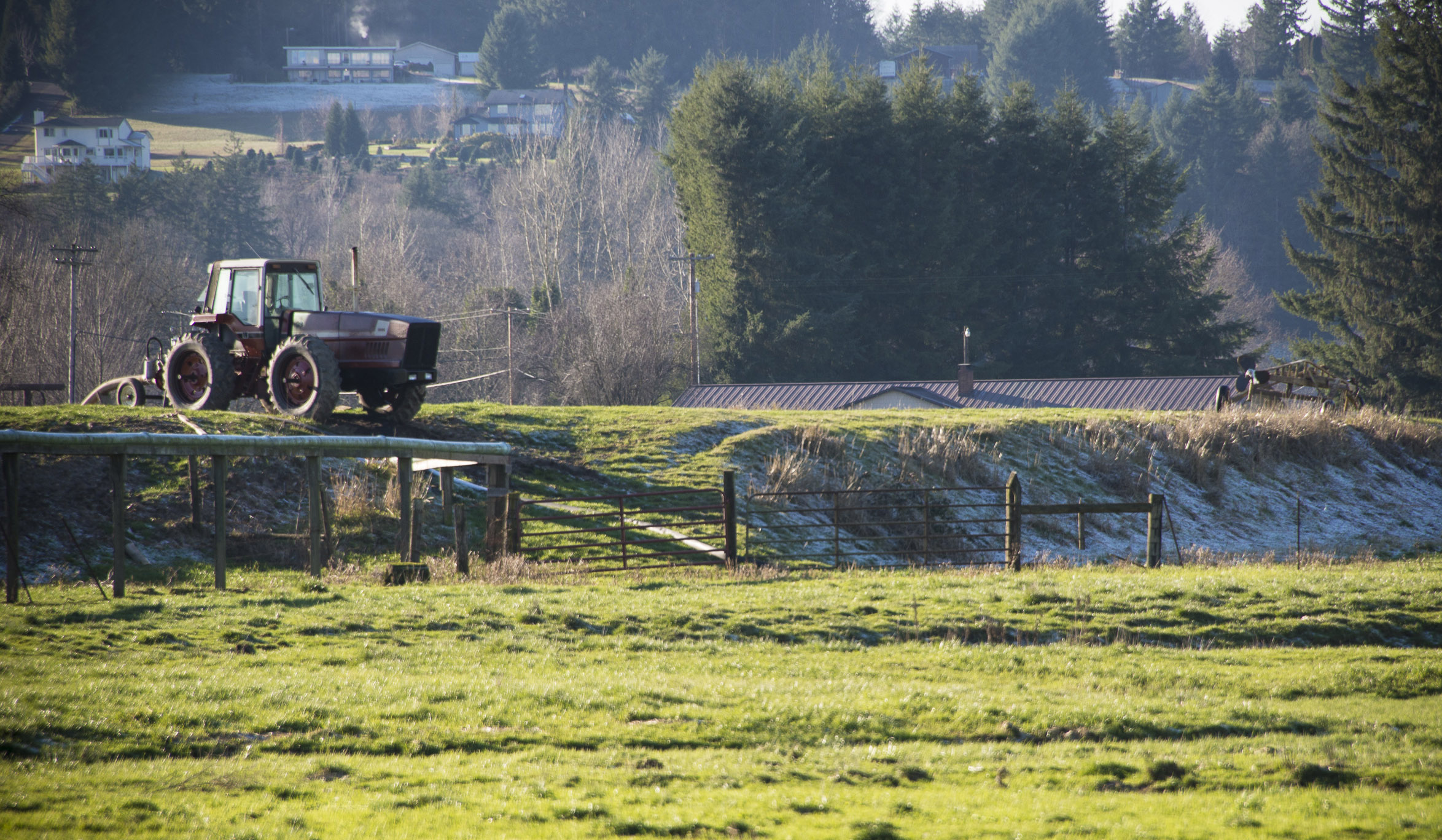
Agriculture
The Chehalis Basin has rich soils, a mild climate and is close to large population centers for markets. As a result, the about 200 working farms in the Basin—both for livestock and crops—produce $650 million in revenue from agriculture annually (including the “economic multiplier” effect of local jobs).
The value of livestock was greater in all counties except Grays Harbor, where the value of crops and livestock production are about equal (in 2017). Agricultural sales for the four main counties in the Basin are shown below (note that these sales are for entire counties, not just the portion of the county in the Basin).
Agriculture Sales by County, 2017
| Grays Harbor | Lewis | Pacific | Thurston | |
|---|---|---|---|---|
| Market Value | $33,598,000 | $136,345,000 | $38,877,000 | $176,090,000 |
| Percent Value Crops/Livestock | 52%/48% | 26%/74% | 19%/81% | 32%/68% |
Historically, heavy dairying led to areas of the watershed failing to meet water quality standards for fecal coliform. That had an impact on water quality in the surface water used, fish, human contact recreation areas and the quality shellfish harvesting areas. Major water cleanup activities began in the early 1990s, including removing livestock from stream areas, implementing dairy waste management plans, restoring riparian areas, installing erosion control practices, nutrient management activities building manure containment structures, restoring wetlands, controlling stormwater runoff, and improving septic systems. All dairies in the Chehalis River watershed are now fully implementing farm management plans—these new plans have significantly reduced bacteria discharges into water. Bacteria levels at all Chehalis River basin monitoring sites now meet the applicable water quality standards.
Most of the agricultural lands—just under 300 square miles—are within low-lying valleys west of the Chehalis River and along its major tributaries (the South Fork Chehalis, Newaukum, Skookumchuck, Black, Satsop and Wynoochee Rivers and Scatter Creek). When the rivers flood, the agricultural land also floods.
Although cultivated cropland represents less than one percent of the total land area there, almost half the land along the main stem of the Chehalis River is in agricultural use (including pasture for livestock).
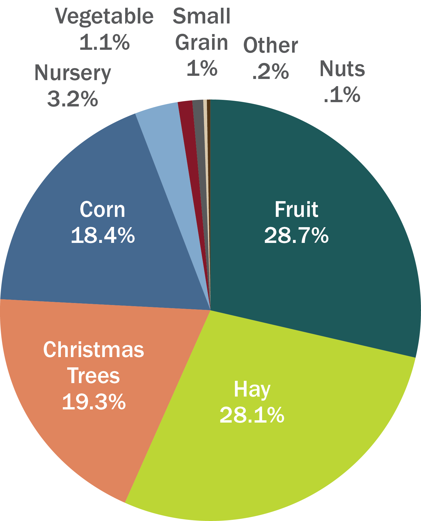
Principal crops include fruits such as blueberries, cranberries and rapes, alfalfa, Christmas trees, hay and silage, corn with some nursery stock, vegetables and small grains. It’s expensive to run an agricultural business and returns are relatively low. An unpredictable climate, including flooding and drought, can make farming difficult. But farmers are now employing improved irrigation efficiency, soil protection techniques and crop rotations, along with participating in the federal Conservation Reserve Program which offers both farmers and ranchers an annual fee for removing environmentally sensitive land from production.
Agricultural Crops
FOOD AND FUN
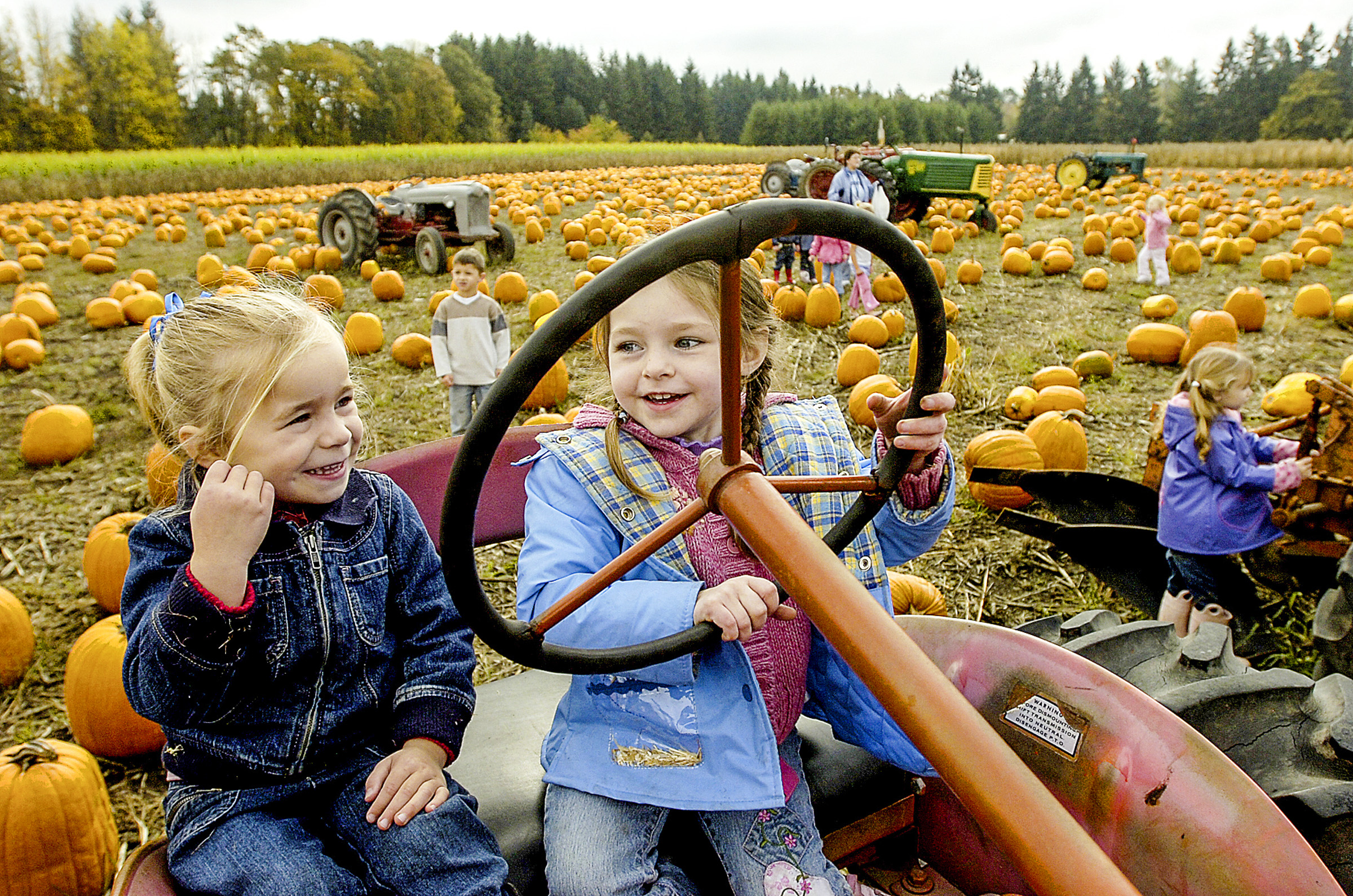
Agritourism is now also a growing industry, bringing visitors from throughout the region to farms in the Chehalis Basin for food and recreation. Farm Guides now direct tourists to farm tours, fruit and vegetable picking and sales, on-site farm dinners, farmto- table restaurants, festivals, venue rentals, classes and workshops, and children and family activities. Farmers markets bring together producers from smaller communities such as Adna, Onalaska, Rochester and Oakville to the Greater Lewis County Community Farmers Market. Other farmer’s markets include those in Centralia, Chehalis and Pe Ell, which include cheeses and handmade products, live music and children’s programs.
Ecosystem Services
Ecosystem services are essential to human survival—breathable air, drinkable water, available food and stable atmospheric conditions. Cultural services are the nonmaterial benefits that people receive from ecosystems through recreation, reflection, aesthetic experiences, spiritual enrichment and cognitive development. Although it’s not really feasible to quantify or monetize cultural services, they are vitally important. Through nature, many traditions and ancestral experiences are shared across generations, enabling the passing down of knowledge, customs and intangible attributes.
The QIN sponsored a 2020 study called the “Economic Value of Chehalis Basin Ecosystem Services” by Resource Dimensions. “From an ecological economics perspective, the goods and services provided by the Chehalis Basin landscapes are both vital to the functioning of the regions ecosystems and contribute significantly to the human welfare of the Basin’s residents…For example, salmon is a cultural foundation, as well as economic, with important cultural ties to local customs and traditions and identity.”
Ecological economics addresses the relationships between natural ecosystems and human economic systems by accounting for the natural environment as a form of natural capital and valuing the goods and services delivered by those ecological systems.
“The Chehalis Basin provides an estimated minimum of $1.1 to upwards of $15.7 billion in ecosystem service benefits annually,” the study finds. During the next 100 years, the Chehalis Basin will provide “$49.1 billion to $233.7 billion.” The wide range reflects a conservative approach, and the study notes that even the high range might be an underestimate.
Intact, healthy ecosystems provide ecosystem services in perpetuity—at no cost to humans. Manufactured capital is natural capital changed by human actions. For example, constructing and operating agricultural systems, timbering, building cities, dams and navigational dredging are examples of manufactured capital that has reduced the historic natural capital.
The Study concludes that “the benefits described…will continue to provide important inputs to Chehalis Basin communities and the regional economy, if actions are taken to protect the region’s land and waters.”
Value of Ecosystem Services
| Low | High | ||||
|---|---|---|---|---|---|
| Total Value ($/acre/yr) | Total Value ($/acre/yr) | ||||
| Land Cover Class | Acres | Min | Max | Min | Max |
| Beach | 181 | $4,505,274 | $19,842,969 | $4,735,897 | $21,095,890 |
| Estuary | 59,989 | $49,603,557 | $974,290,768 | $54,723,527 | $1,149,545,636 |
| Rivers & Lakes | 12,349 | $21,786,729 | $262,518,378 | $25,637,921 | $295,506,680 |
| Wetlands | 89,636 | $381,682,803 | $5,414,576,450 | $393,290,761 | $5,673,477,518 |
| Cropland | 14,967 | $14,349,924 | $39,035,710 | $14,893,373 | $40,382,763 |
| Forests | 887,280 | $539,136,435 | $7,163,780,868 | $588,927,586 | $7,854,730,675 |
| Grasslands | 136,598 | $35,801,102 | $259,654,299 | $36,982,090 | $269,690,666 |
| Pasture | 79,036 | $11,243,799 | $39,713,808 | $12,806,181 | $43,758,074 |
| Scrub/Shrub | 353,956 | $54,596,872 | $189,616,631 | $68,089,678 | $231,010,531 |
| Urban Green Space | 13,335 | $27,677,747 | $90,223,491 | $30,203,713 | $98,725,619 |
| Total | 1,647,328 | $1,140,384,242 | $14,453,253,371 | $1,230,290,727 | $15,677,924,052 |
POPULATION
Over 190,000 people now call the 2,700-square-miles of the Chehalis Basin area home. The area is planning for growth— about 220,000 are projected to live in the Basin by 2025.
Another four counties share a combined total of 3% of the Basin: Pacific, Cowlitz, Jefferson and Wahkiakum.
The Basin has lower population and housing density than the state average, although the average household size is similar to the state average. Income is lower than the state average across all metrics. Most of the population has a high school education, followed by some college but no degree. Most families own the home they live in, but the average median home income is lower than the state average.
Growth is predicted to continue beyond 2025 as well. The Washington State Employment Security Department estimates that the population of the Basin will increase by about 42,000 people by 2040; Grays Harbor County as a whole will increase about 3% by 2040, Lewis County by 12%, Mason County by 27%, and Thurston County by 27%.

Population Characteristics
| Quinault Reservation | Chehalis Reservation/ Off-Reservation | Chehalis Basin | Grays Harbor County | Lewis County | Washington State |
|
|---|---|---|---|---|---|---|
| Population | 1,272 | 847 | 192,881 | 71,734 | 75,382 | 6,899,123 |
| Population Density (sq. mile) | 4.1 | 124.2 | 71.4 | 38.3 | 31.4 | 101.2 |
| Housing Density (sq. mile) | 1.5 | 41.1 | 32.4 | 18.5 | 14.2 | 43.4 |
| Average Household Size | 3.19 | 3.47 | 2.4 | 2.51 | 2.52 | 2.55 |
| Median Household Income | $29,659 | $39,318 | $50,265 | $43,379 | $42,917 | $60,294 |
| Owner Occupied Housing | 61.1% | 57% | 67.8% | 69% | 67.8% | 62.7% |
| High School Degree | 34% | 41.1% | 29.5% | 31.4% | 32.2% | 23.3% |
| BA Degree | 9.3% | 7.4% | 13.4% | 10.5% | 8.6% | 20.6% |
Population Centers
Aberdeen/Hoquiam
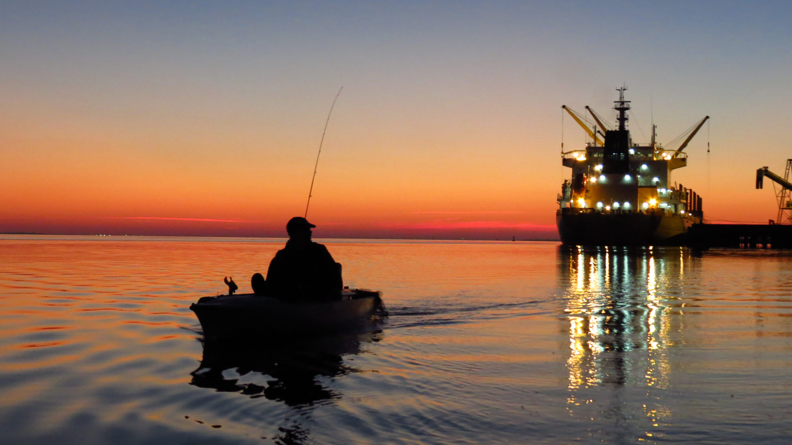
The sister cities of Aberdeen and Hoquiam— located at the very western edge of the lower Basin—have separate and unique identities, but share the bounty of Grays Harbor, the sports fishing capital of Washington.
Aberdeen sits at the mouth of the Chehalis River and is the economic center of Grays Harbor County with a population of just over 17,000. It was incorporated in 1890; it might have been named for Aberdeen in Scotland (where it translates to mouth of the river), or it might have been named for the Aberdeen Packing Plant, a cannery that had recently opened. The town struggled to transport goods and people overland into the interior because roads were often little more than glorified trails. In 1892 Northern Pacific offered Aberdeen a direct a line, if they built it themselves. They did. And the line began running in 1895.
By 1900, logging and sawmills were booming. Aberdeen was home to six sawmills, two shingle mills, a stave factory, two shipyards, three canneries, two hospitals, three schools, numerous churches and two theaters. In 1924, a new milestone for annual lumber production was reached when the one billionth foot of timber was shipped from Aberdeen, earning the town the title of “Lumber Capital of the World.”
The City was hit hard during the Great Depression, when the number of major local sawmills reduce from 37 to nine. Today, Aberdeen’s economy is based on timber, fishing and tourism industries and it serves as a regional service center for much of the Olympic Peninsula. Along with its sister city, Hoquiam, it hosts the Port of Grays Harbor: the largest coastal shipping port north of California, the center for the export of logs from the West Coast and one of the largest centers for the shipping autos and grains to China and Korea.
Aberdeen is also the birthplace of “grunge rock” and the rock group Nirvana; the City’s slogan, “Come as you are,” is in honor of lead singer Kurt Cobain.
Hoquiam translates to “hungry for wood,” because the mouth of the Hoquiam River where it sits, used to be choked with driftwood. Established in 1867, Hoquiam’s first logging mill was built in 1894 and eventually the dense forests supported almost 40 lumber mills. Logging was the main industry for many years, and during the lumber heyday of the 1920’s, loggers were working 30–50 miles back in the hills. But logging began to decline in the late 1920s and by the 1990s all logging in old-growth forested lands was completely suspended.
A rise in tourism has helped stabilize the economy. Along with Aberdeen, Hoquiam serves as a southern gateway to the Olympic Peninsula, Olympic National Park, the Olympic National Park beaches—and all the tourists they attract. The two cities also host the Port of Grays Harbor, the closest shipping port to Asia.
With a population of about 8,800, Hoquiam’s economy is diversifying and growing healthier. The historic downtown boasts the restored 7th Street Theater, the first theater in the Northwest. In addition to the remaining logging, plywood and paper pulp endeavors, the town now has breweries, farmers markets, yacht-building and the largest biodiesel manufacturing plant in the nation, capable of producing more than 100 million gallons of biodiesel per year.
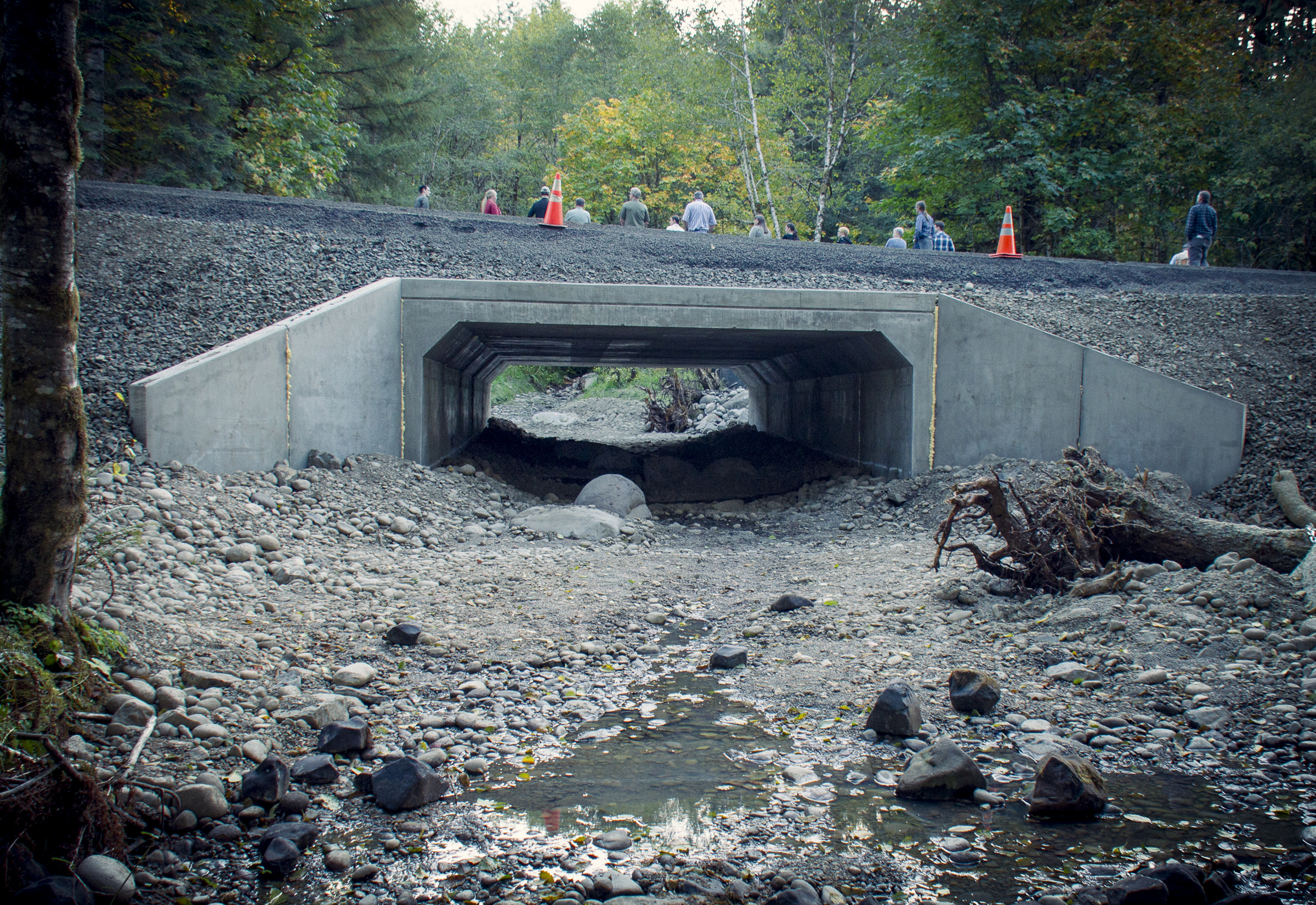
Flood Damage Reduction Project
To help protect low-lying areas, the two cities are investing $78 million to design and construct 10.9 miles of levees along the Chehalis and Hoquiam Rivers and across the low-lying land near the harbor. The Chehalis Basin Strategy has provided $18 million for the project, which will be completed in four phases.
Source: Office of Chehalis Basin
Adna
Unincorporated Adna, in the rural farm country of Lewis County, is next to the Chehalis River about six miles south of the City of Chehalis. The town has had many different names, settling on Adna in 1894. It’s actually too small for an official census count; it’s simply called a “populated place.” However, the Adna School District serves a population of about 3,500. Adna boasts many acres of fertile farmland, a school district, small center, a post office in the grocery store and trailhead access to the famous Willapa Hills Trail, a 56-mile intercounty trail.
Chehalis
At a point almost exactly between Seattle and Portland, straddling Highway 5, is the City of Chehalis. With a population of about 7,700, it is also the county seat of Lewis County.
Chehalis began in 1873 as a settlement around a warehouse beside a Northern Pacific Railroad track. Several houses soon popped up, along with a store, a courthouse, and other businesses. The little town began calling itself “Chehalis” in 1879 to denote its location near the Chehalis River and it was incorporated in 1883.
Logging in the nearby forests attracted workers from Scandinavia, England and Scotland. By the mid-1900s the economy shifted towards farming and the chief local industries were dairy, poultry, fruits, brick and tile manufacturing, coal mining and portable house manufacturing.
The historic downtown and most of the city’s amenities lie on the east side of the freeway nestled at the base of forested hills. On the west side of the freeway are parks, farms, housing subdivisions and centralized shopping district, the Twin City Town Center.
The Chehalis–Centralia Airport, just west of the freeway, opened in 1927. It played a role in World War II as a training facility for new pilots. While it does not have commercial flights, it averages about 130 private flights a day.
Source: Office of Chehalis Basin
Centralia
Centralia began as site of a toll ferry at the confluence of the Chehalis and Skookumchuck rivers, and the center stopping point for stagecoaches between Kalama and Tacoma. As a small settlement, it was then called Skookumchuck. Military Road, the first road to come through the valley, passed through Skookumchuck just west of where I-5 runs today. While Skookumchuck had a post office, a stagecoach stop and a store or two, it remained more or less a cluster of settlers until the railroad came to town in 1872. With its central location on the line, the settlement inevitably became Centerville in 1875. The railroad brought access to outside markets for farm produce, lumber and coal—at one time, five railroad lines crossed the town! It was renamed Centralia in 1883 because of confusion with Centerville in Eastern Washington. Soon, the town had a school, hotels, shops, flourmills, shingle mills and many, many sawmills.
Centralia had ups and downs through the late 1800s and early 1900s. Centralia College, founded in 1925, is now oldest continuously operating junior college in the state of Washington. After World War II, Centralia remained a logging and mining town, and in 1951 the White Pass Highway crossed the Cascades and opened markets: timber products went east and agricultural products—and tourists—came west. In 1980, the explosion of Mount St. Helens destroyed or damaged much of the areas stockpiled lumber and salable timber, which devastated an industry already in decline.
But Downtown Centralia reinvented itself as a historical district and has found new life as a shopping destination. Based on its central location between Seattle and Portland, major retailers opened factory outlets, which led to redeveloping the vintage downtown marketplace, now an antique, art and specialty store destination.
Centralia is experiencing growth in both its light industry areas as well as its core business district. And new regional distribution and transportation facilities, along with in-migration from retirees from more populated counties to the north, have helped diversify the economy. It’s seen a 60% growth in population during the past four decades; over 18,000 people now live there.
FLOOD DAMAGE REDUCTION PROJECT
Centralia’s China Creek floods every 5-10 years. Centralia and the Confederated Tribes of the Chehalis Reservation have partnered to reduce flood damage and reopen the creek to fish passage by planting trees to create a more complex channel and increasing water storage in the Creek’s upper reaches. Phase 1 of the project was completed in late 2019.
Source: Office of Chehalis Basin
Cosmopolis
Cosmopolis is the oldest city in Grays Harbor, established in 1852 and incorporated in 1891. The name means “city of the world,” but locals prefer to use the city’s nickname, “Cosi.” In 1880, the Grays Harbor Mill Company opened the region’s first saw mill here on the banks of the Chehalis. As did other Chehalis Basin towns, Cosmopolis boomed as logging boomed. In 1957, the Weyerhaeuser Company purchased property for a pulp mill, producing grades of pulp in such diverse products as photographic papers, plastic molding compounds, acetate yarns, cigarette filters, toothpaste, and air-laid toweling. The mill now manufactures specialty pulps, much of which is exported to Asia, and has brought vitality to the town. Starting in the 1960s, Cosmopolis developed residential areas on the hills. The population has not risen much since then— about 1,700 today.
Elma
Located about 40 miles east of Grays Harbor, Elma lies in the lower Chehalis River Valley. It was either named for Elma Austin, whose family settled in the area before 1860, or for a Union soldier…there are several other possibilities.
It was incorporated in 1888, and the logging and agriculture in the area attracted Scandinavian, Polish and German immigrants, as in other Chehalis Basin cities and towns. Residents of Elma and the surrounding communities also relied on dairy, poultry, truck gardening and bulb growing and the town was a trading center for woodworks and loggers.
Elma is now the site of the Grays Harbor County Fairgrounds and its downtown boasts 22 historic murals. Its population has been steadily rising and is now about 3,500, with major industries being accommodation and food services as a gateway to the Olympic Peninsula, along with agriculture, forestry and fishing. Despite being a small town, it boasts a modern utility structure, including a state-of-the-art sewage treatment facility and fiber optic pipelines.
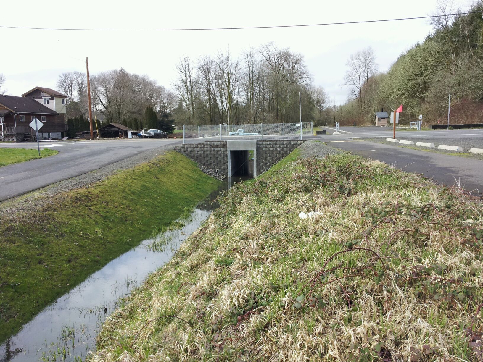
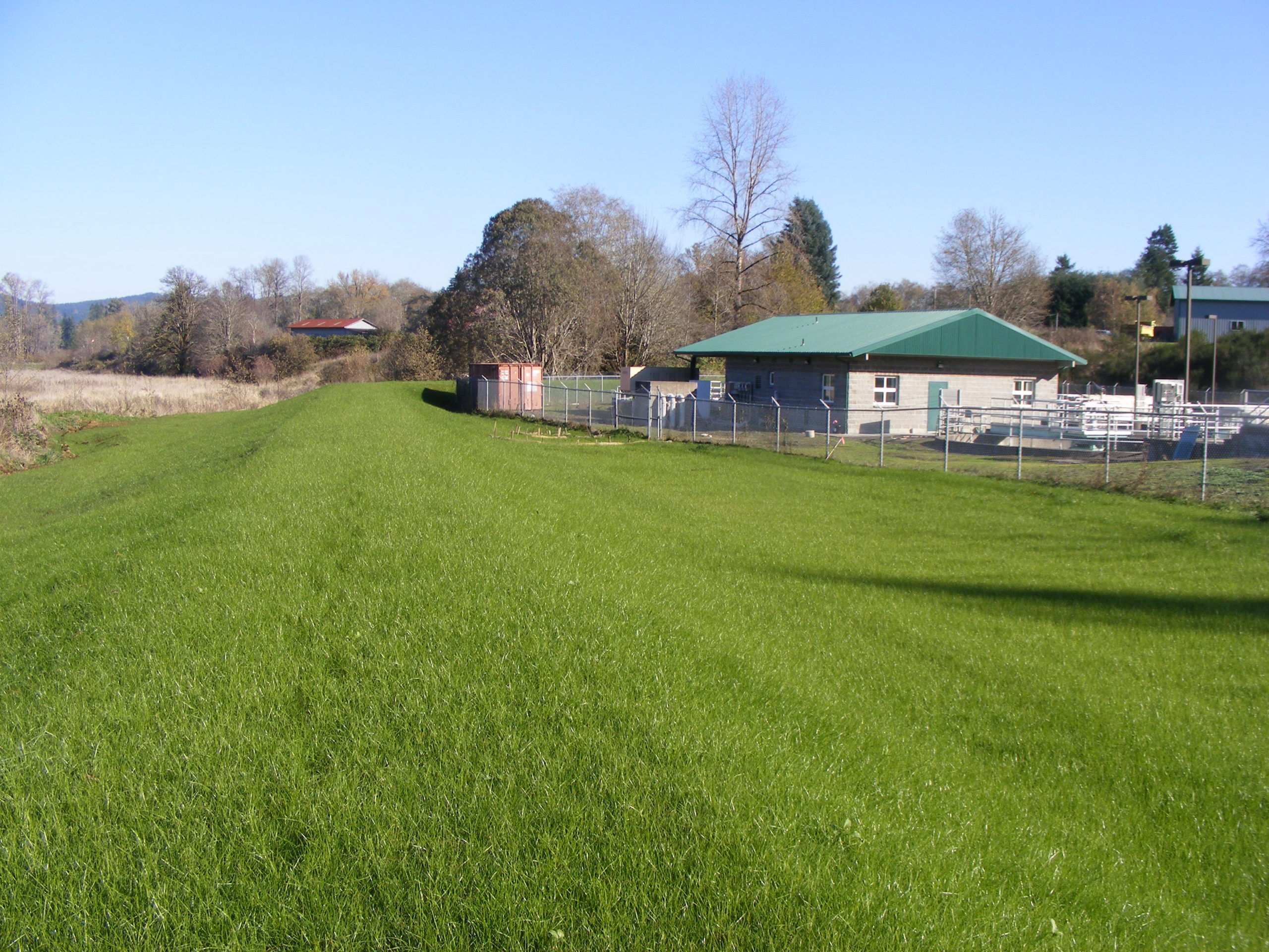
FLOOD DAMAGE REDUCTION PROJECT
The city’s wastewater treatment plant is along the banks of the Wynoochee River, which has been seriously eroding and threatened to breach the dam, sending raw sewage downriver to the Chehalis and Grays Harbor. The firstphase solution in 2018 included log jacks on the banks, large structures made up of logs and boulders that slow water and mimic aquatic habitat. The second phase in 2019 involved more log jacks placed in the river directly adjacent to the plant’s sheetpile walls, which is slowing water and erosion, and creating fish habitat.
Source: Office of Chehalis Basin
Pe Ell
Located high in the hills of the upper watershed, Pe Ell has a population of about 650. The site was established was established by farmers in the 1850s, but the local industry soon switched to logging.
The proposed dam would be located just above the town.
There are many stories about how this town got its name (someone’s initials—PL—a railroad map designation, a mispronounced name, etc.), but none have been verified as the one true story. Simply, it started growing in 1897 when the North Pacific Railway built a railroad depot in the town, about 25 miles east of Chehalis. In 1900, Weyerhauser bought 900,000 acres in the area for logging. When it incorporated in 1906, Pe Ell’s population was about 1,000—larger than it is today. The rich agricultural and timber resources of the region attracted farmers, millworkers and loggers. The town then had a bank, three dry goods stores, two general stores, three grocery stores, two barber shops, four hotels, five saloons, a newspaper and even an opera house! The town today is also the starting point of the Pe Ell River Run with entrants floating down the Chehalis River in mostly homemade crafts, ending at Rainbow Falls State Park.