project background
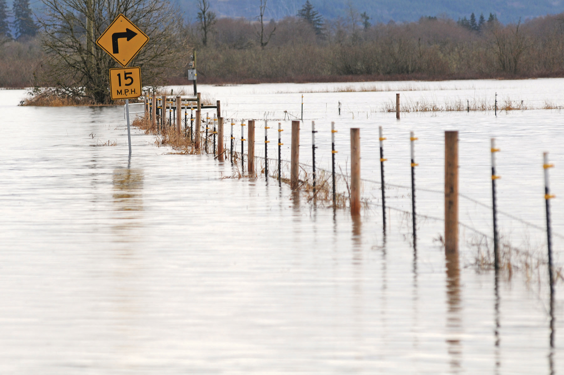
Flooding is a normal part of the Chehalis basin’s ecology, with minor flooding every two-to-five years, and a major flood every 10 years or so.
The past decades have seen intensive land use and man-made changes to river flows. And climate change has made heavy rains and flooding more common.
HISTORY OF FLOODING
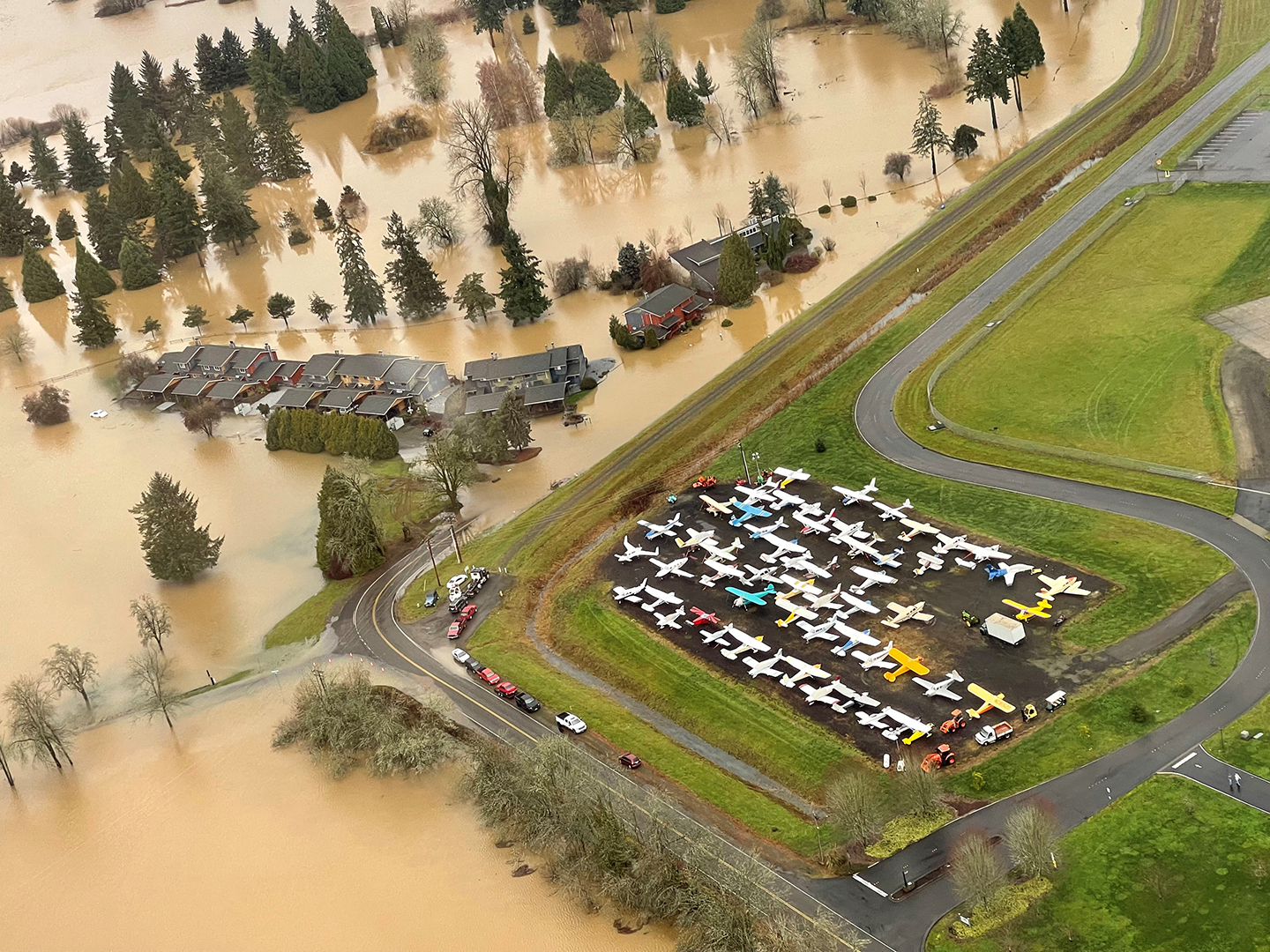
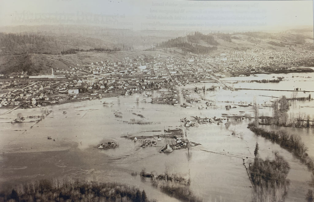
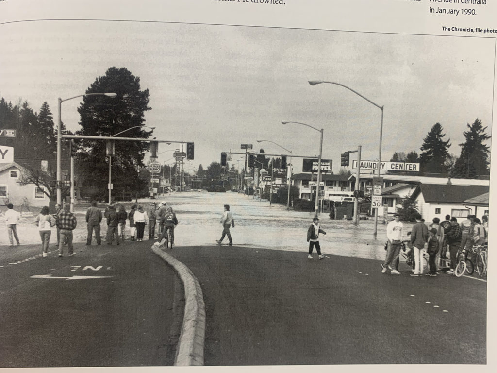
Within the last 50 years, major floods occurred in 1972, 1975, 1986, 1990, 1996, 2007, 2009 and 2022. With the impacts of climate change, flooding has become increasingly severe—the 1996, 2007, 2009 and 2022 floods are the four largest floods on record, and the 2007 and 2009 floods occurred only 14 months apart.
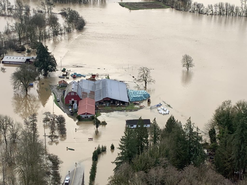
Flooding puts homes, businesses, towns, and fish and wildlife at greater and greater risk. Now, climate change is making the situation potentially catastrophic. The Chehalis Basin Strategy is bringing people together across the Basin to halt and reverse the devastating decline of salmon and other aquatic species and protect communities and landscapes from the predicted increase of flooding disasters.
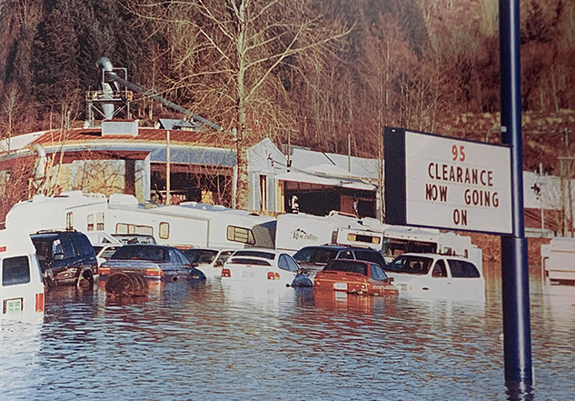
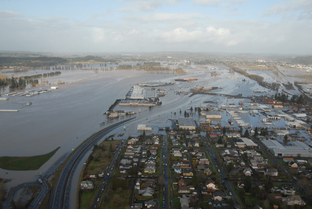
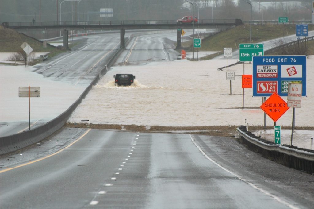
As flood events become ever more common and intense, local communities bear the impacts. Much of the damage from recent major floods occurred in Chehalis and Centralia, where there has been more development in the floodplain than in other areas of the Basin. The 1996, 2007 and 2009 floods all resulted in the loss of homes, farms and businesses, and multi-day closures of Interstate 5.
To address the challenges of flooding and develop strategies to reduce flood damage and restore habitat for aquatic species, Washington State, local leaders and the people of the Chehalis Basin created the Chehalis Basin Strategy. The Strategy is an ambitious collection of potential actions to improve and restore river habitat and reduce flood damage. It is a basin-wide approach that includes both near- and long-term actions, as well as smalland large-scale projects. The overarching goal of the Strategy is to make the basin a safer place for families and communities impacted by flooding, and to improve and restore aquatic species habitat now and for future generations.
THE X-YEAR FLOOD
The term “X-year flood” describes the recurrence interval of floods. A 100-year flood has a 1 in 100, or 1%, chance of occurring in any given year. A 500-year flood has a 1 in 500, or 0.2%, chance of occurring in any given year. It’s certainly possible to have a 100-year flood after only a few years. And the fear is that the Basin will have 100-year floods more frequently in the future.
CUBIC FEET PER SECOND
Water flow is measured in cubic feet per second (cfs) flowing past a specific point. One cfs is just under 7.5 gallons. Normal summer low flow at one gage on the Chehalis (at Doty) could be just 225 gallons a second. Normal winter high flow (at Porter) could be as much as 57,000 gallons a second but well-contained in the river.
2022 FLOODING DAMAGE IN THE BASIN
Lewis County:
$3,996,744 in public damages (reported by cities and taxing districts)
$1,613,774 in individual damages (reported by 141 residents and 10 businesses)
Thurston County:
$2,640,000 damages total (public infrastructure and private)
$1,400,000 in private industry damages (reported by 100 residents and two businesses)
Grays Harbor County:
$800,000+ in public damages (across 12 jurisdictions)
$3,127,145 in primary residence damages (structure and personal property)
$265,200 in business damages (structure, furnishings, inventory, etc.)
Note: Preliminary numbers
Flood Retention Dam
Following the Programmatic Environmental Impact Statement conducted by the Department of Ecology, the Chehalis Basin Board approved submitting the flood retention facility for a more detailed environmental review.
In 2018, the Chehalis River Flood Control Zone District (“the District”) submitted for more detailed environmental review a proposal for constructing a 1,220 a 1,220 foot-long dam and associated temporary reservoir south of Pe Ell on the Chehalis River. In addition, the proposal also called for significant improvements to levees around the Centralia- Chehalis Airport.
According to the District, the proposed dam would significantly reduce flood damage, but would not protect all communities from all flooding.
Since the project would fall within both state and federal jurisdictions, the Washington State Department of Ecology prepared and released a draft state environmental impact statement (EIS) in February 2020 and the U.S. Army Corps of Engineers prepared and released a separate federal draft EIS in September 2020.
Community Feedback
Communities across the Basin have differing views on the project.
Project proponents, including the Chehalis River Flood Authority and Chehalis and Centralia City Councils, have highlighted the following potential positive outcomes:
- Reduction in the amount of flooding for residents of Chehalis and Centralia
- Reduction in flood depths in Chehalis, Centralia and the area from Pe Ell to just upstream of the confluence of the South Fork Chehalis River
- More than 1,200 families protected from catastrophic flooding
- Elimination of flooding for 43% of homes, businesses, schools and other structures— the majority of remaining structures could be protected via local projects
- Elimination of flooding at key locations along I-5 and reduced freeway closure times
Project opponents, including the Confederated Tribes of the Chehalis Reservation, the Quinault Indian Nation and many environmental organizations, have highlighted the following potential negative outcomes:
- Reductions in aquatic species such as spring- and fall-run Chinook salmon, Coho salmon and steelhead trout
- Degraded habitat and river and stream water quality, including tree removal at the reservoir site, increased water temperatures up to 5-9°F and decreased levels of dissolved oxygen
- Impacts on tribal and cultural resources, including sites of significant spiritual importance on tribal lands, in violation of federal treaties
- Lost recreational opportunities, including 14 miles of kayaking and 13 miles of riverbank fishing
- Lack of clear funding to build the proposed dam—estimated to cost at least $600 million or as much as $1 billion, depending on the source
- Lost restoration opportunity: The upper Chehalis River where the dam would be built is relatively undeveloped and offers good habitat restoration opportunities, especially for spring Chinook
If the proposed project moves forward into a final environmental review and permitting stage, additional adverse impacts could be identified. The Flood District would be required to propose plans to avoid, minimize or mitigate negative impacts as requirements of obtaining permits.
The Office of Chehalis Basin and the Tribes remain committed to finding solutions for both reducing flood damage and improving aquatic species habitat.
Source: Office of Chehalis Basin
Source: Chehalis River Basin Flood Authority
Chehalis Basin Timeline: The Last 100 Years
MINOR, MAJOR, CATASTROPHIC?
Minor flooding usually results in minimal or no property damage, but there might be some public threat. Those will likely happen with great regularity.
A major flood (100-year) on the Chehalis River is when water is flowing at more than 38,800 cfs at the Grand Mound gauge. A catastrophic flood (500-year) is water flowing at more than 75,000 cfs.
The Quinault, Chehalis, and other tribes have called the Chehalis Basin home for centuries. This is their ancestral land.
Settlers arriving from points east established townships in the Chehalis Basin starting around the 1850's.
Bylaws form early foundations of Quinault Indian Nation
Annual production of timber reaches 1 billion board feet
Centralia College founded
Chehalis-Centralia Airport opens
Major Flood Event
Major Flood Event
Confederated Tribes of the Chehalis Reservation formed
Weyehauser opens first tree farm, in Montesano
Final section of Highway 5 opens in Washington
Major Flood Event
Chehalis Reservation amends Constitution
Boldt Decision re-affirms tribal access to nonreservation fishing grounds
Constitution of the Quinault Indian Nation ratified
Major Flood Event
Major Flood Event
Quinault Nation implements self-governance
Tree sales limited on both private and public lands to protect the Spotted Owl
Major Flood Event
Catastrophic Flood Event
Catastrophic Flood
Great Coastal Gale
Major Flood Event
Washington State Office of Financial Management begins funding local Chehalis Basin flood protection projects
State Legislature forms Office of Chehalis Basin (OCB) and Chehalis Basin Board
Department of Ecology releases Programmatic Environmental Impact Statement
37 local flood protection projects completed
66 local aquatic species restoration projects completed
Draft ASRP released
OCB launches Community Flood Assistance and Resilience Program
Army Corps of Engineers releases federal Draft Environmental Impact Statement
Major Flood Event
Major King Tide
Quinault Indian Nation declares Landslide Emergency